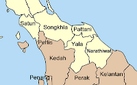
The three southernmost provinces of Thailand - Pattani, Narathiwat and Yala - have always been a trouble area, not just with the onset of the current sprawl of terroristic attacks since 2004 and the sometimes brutal reactions of the Thai military or police, like the Tak Bai incident. One of the keys to understand these problems is the history of the area, and as I focus on the administrative subdivisions in this blog I will just list the main changes within these provinces in the past.
The sultanate of Patani - even during its heyday in the 17th century under the consecutive rule of four queens - was required to pay tribute to the Siamese king in Ayutthaya, but also tried to liberate itself by rebellion which were always fought back, so it only had short intervals of independence. The woodcut to the right titled "
Triumphal procession near the city of Patani" dates from this most glorious period of Pattanis history. After the fall of Ayutthaya Patani enjoyed its last period of independence, until it was returned into submission by the vice-king of Rama I. During this campaign the important cannon named Phraya Tani (or Seri Patani in Malay) was taken as booty to Bangkok, where it is still on display in front of the Ministry of Defense.

Further attempts of rebellion then made King Rama II divide the sultanate into 7
Mueang to reduce the power base of the ruler of Patani and introduce competitions and power struggle between the new city states.
The seven
Mueang created in 1817 were Pattani, Nong Chik, Sai Buri (Teluban), Yala (Jala), Yaring (Jambu), Ra-ngae (Legeh) and Raman. They all were made subordinate of the governor of Nakhon Si Thammarat (Ligor) and later of Songkhla.
The incorporation of these seven states into a centrally governed country began 1874-1892, when the area became known as
Khaek Chet Huamueang (แขกเจ็ดหัวเมือง, Seven Malay States). With the
thesaphiban reforms under the first minister of Interior, Prince Damrong, this integration was put further. In 1901 the name for the are was changed to
Boriwen Chet Huamueang (บริเวณเจ็ดหัวเมือง), and in 1906 the area power of the Malay province governors was reduced considerably with the creation of the
Monthon Pattani (see
Gazette announcement). The monthon governor was a government official sent from Bangkok, while the province governors till then was a mostly hereditary post of a local aristocracy. After the hereditary provincial governor died they were replaced with government official sent from the central government.
The 1909 treaty with Britain on the southern boundary of Siam finalized the inclusion of Pattani into Siam, and is thus often quoted as the annexation of Pattani. In fact it was just the last step of the integration into the modern nation state, which already begun with the defeat in 1785.
Sometime between around the set up of the Monthon and 1917 three of the seven
Mueang were abolished, but I haven't yet found the details on this, especially the year and the Royal Gazette announcement - sadly the announcement on the
monthon creation does not list the constituent provinces. I could however find the last mention of Mueang Raman in the Gazette in 1909, yet that wasn't on its abolishment. The center of Ra-ngae was also changed towards the coast in this time, and in 1915 it was renamed from Bang Nara (บางนรา) to its modern name Narathiwat (
Gazette announcement).
Finally in 1932, the
Monthon Pattani was incorporated into the
Monthon Nakhon Si Thammarat (
Gazette announcement), and just a year later the
Monthon system was abolished altogether.
Together with the abolishment of
Monthon Pattani, the province Sai Buri was abolished, reducing the former 7
Mueang finally into the modern day 3 province. The northern part of Sai Buri was attached to Pattani, the southern part went to Narathiwat.
There is one piece I could not confirm yet - in the
Wikipedia article on Songkhla someone claimed that the tree districts at the border to Pattani - Chana, Thepa and Saba Yoi - were reassigned from Pattani to Songkhla, but instead of a year it was only quoted as "recently". When I found the
list of all districts in 1917 I could at least rule out that recently means in the last decades but if correct it happened at the beginning of the 20th century. But so far I could not find the relevant Royal Gazette announcement on this.
To go down one administrative level, that 1917 list gives the names of all the districts within the
Monthon Pattani, a total number of 19 district and 2 minor districts - today there are 33. Of the districts existing in 1917 just one has been abolished - the minor district Kalapho (
กะลาพอ) in Sai Buri was abolished in 1938 (
Gazette announcement) and incorporated into Taluban (now named Sai Buri) district. All the other listed in 1917 have only experienced name changes, area changes and new districts splitting off. There was one more district which only existed temporarily - in 1935 the minor district Pa Cho (
ปาโจ) was created covering the western part of the district Tomo (
โต๊ะโมะ,
Gazette). 1939 Tomo was renamed to Waeng, and Pa Cho to Tomo (
Gazette), and in 1953 Tomo was abolished (
Gazette). Most of its former area now forms the district Sukhirin.
The two-volumed book
Hikayat Patani is on the chronicle of the sultanate, however this source end in the first half of the 19th century. The
second book on the history of Pattani was written under a pseudonym, nothing is know about the author. For the early history it relies on the
Hikayat Patani, but it continues till the middle of the 20th century.


