Showing posts with label Regions. Show all posts

Wednesday, May 11, 2011

Bueng Kan news

Again, some shorter news on the new province and it starting with being operational.

On May 3, the Royal Gazette contained the update on the province cluster regulation [Gazette], which now placed Bueng Kan into the cluster Upper Northeast 1 (ภาคตะวันออกเฉียงเหนือตอนบน 1) - not really surprising because Nong Khai was already in this cluster, so the boundaries of the cluster weren't changed, only the list of provinces within was extended.

In the cabinet meeting on May 4th, the nomination of Somphon Arunrotpanya (สมพงษ์ อรุณโรจน์ปัญญา) as first governor of Bueng Kan was approved. He already served as acting province governor since the province was established, but still was primary a deputy governor of Surin province.

And like for all other parts of Thailand, the Election Commission has announced the constituencies for Bueng Kan, which has been divided into two constituencies each covering four districts. Constituency One covers the districts Mueang Bueng Kan, So Phisai, Pak Khat and Bung Khla; Constituency Two the districts Seka, Phon Charoen, Si Wilai and Bueng Khon Long.

And finally, the province administration has started their website, same as all other provinces it has its own site in a go.th domain. Well, actually, the name bungkan.go.th isn't yet known in the name servers, but it is found in the header graphics, right now the site can only be found at an IP address assigned to the Ministry of Education. There isn't much content yet, some news, the resume of the province governor and the history and geography of the province. And I was visitor number 472.

Friday, March 6, 2009

Regions and Vice-Roys 1915 to 1925

One quite unknown historical subdivision were the regions created in 1915 after the resignation of Prince Damrong, officially due to health reasons but it was an open secret that the prince did not get along with the new king well. The only thing I know about these regions is the following paragraph in Tej Bunnags "The Provincial Administration of Siam 1892-1915".
Changes were also made in Prince Damrong's Thesaphiban system of provincial administration. Five months after his acceptance of the Prince's resignation, the King issued the Announcement of 13 December 1915 concerning the duties and powers of Viceroys. According to this Announcement, the country was to be divided into regions (phak), over which were to be placed Viceroys (Upparat) who were to be appointed by the King. The superintendent commissioners were to remain at their posts but they were to consult with the Viceroys before they undertook to deal with any emergency or any matter not covered by existing acts and regulations, before they submitted annual accounts of their monthons' revenue and expenditure to the Ministry, and before they appointed, transferred, promoted, recommended for decorations, demoted or dismissed officials upwards from the rank of district officer. In that year, the King placed Viceroys over the Phayap Region, which consisted of monthon Phayap and Maharat, and the Western Region (Phak Tawan-tok), which consisted of monthons Nakhon Chaisi and Ratburi. In 1916 and 1922, he placed Viceroys respectively over the Southern Region (Phak Tai) which consisted of monthons Chumphon, Nakhon Sithammarat, and Pattani, and the Isan Region which consisted of monthons Roi-et, Ubonratchathani, and Udonthani.
Map of the regionsAs in a footnote the author gave the title of the announcement mentioned in the text, I was able to find it in the Royal Gazette database - พระบรมราชโองการ ประกาศ ว่าด้วยหน้าที่และอำนาจอุปราช However I could not find anything on those regions introduced later, nor seem there be any list of the Monthon within the two regions established in 1915. But the whole system was rather short-lived anyway, since these regions were abolished in 1925.

As one can see in the map by the yellow parts, these regions with their vice-roys did not cover the whole country - the monthon Phuket and Nakhon Ratchasima were not part of the south or Isan region respectively, and for the whole central and eastern region there did not have regions applied at all.

Wednesday, January 7, 2009

Regions defined by DOPA

I mentioned them shortly while presenting the district officers of the year earlier - the list of finalists for that award shows the provinces grouped into 12 regions named Khet (เขต). Not to be confused with the district in Bangkok which are also named Khet; and as the head officers of the Bangkok districts are not appointed by DOPA Bangkok isn't included into the following list anyway.
  • Region 1: Chiang Mai, Tak, Mae Hong Son, Lampang, Lamphun
  • Region 2: Chiang Rai, Nan, Phayao, Phrae, Sukhothai, Uttaradit
  • Region 3: Kamphaeng Phet, Nakhon Sawan, Phichit, Phitsanulok, Phetchabun, Uthai Thani
  • Region 4: Nonthaburi, Nakhon Pathom, Pathum Thani, Phra Nakhon Si Ayutthaya, Samut Songkhram, Samit Sakhon, Ang Thong
  • Region 5: Chachoengsao, Nakhon Nayok, Prachinburi, Lopburi, Saraburi, Singburi
  • Region 6: Chanthaburi, Chonburi, Trat, Rayong, Samut Prakan, Sa Kaeo
  • Region 7: Kanchanaburi, Chainat, Prachuap Khiri Khan, Phetchaburi, Ratchaburi, Suphanburi
  • Region 8: Nakhon Phanom, Loei, Sakon Nakhon, Nong Khai, Nong Bua Lamphu, Udon Thani
  • Region 9: Khon Kaen, Chaiyaphum, Nakhon Ratchasima, Buriram, Maha Sarakham, Surin
  • Region 10: Kalasin, Mukdahan, Yasothon, Roi Et, Si Sa Ket, Amnat Charoen, Ubon Ratchathani
  • Region 11: Chumphon, Nakhon Si Thammarat, Ranong, Surat Thani, Krabi, Phang Nga, Phuket
  • Region 12: Trang, Phatthalung, Narathiwat, Pattani, Yala, Songkhla and Satun
The 13th entry in the list is a special mention for the outstanding district officer at the southern boundary districts of Yala, Pattani and Narathiwat.

I don't know if these twelve regions are used for other administrative tasks with DOPA as well, or were just created for this district officer award.

Wednesday, September 17, 2008

Regions of the Public Relations Department

As I mentioned before, the regions nowadays are not clearly defined, and even the different departments or ministries of the government use their own definition. While the ones used in the census data and those by the Ministry of Interior are probably the most important ones, they are by far not the only region definitions used. The Public Relations Department (PRD, กรมประชาสัมพันธ์) is subdivided into 8 regional offices, each responsible for several provinces. Each of these regional offices works as a news agency for their area, so on the websites of each regions one can find all the local news - sadly only in Thai. Apparently each of the regional offices creates their website independently, thus their all have a different look, some display quite ugly in Firefox and only work well in Internet Explorer, some have a RSS feeds for their news while most don't have one. But almost all are cluttered with bitmaps, animations or sliding texts, definitely not looking like being made by a professional web designer.
  1. Region 1: Khon Kaen, Nakhon Ratchasima, Udon Thani, Nong Khai, Loei, Maha Sarakham, Kalasin, Chaiyaphum, Sakon Nakhon, Nong Bua Lamphu
  2. Region 2: Ubon Ratchathani, Sisaket, Surin, Buriram, Yasothon, Roi Et, Amnat Charoen, Mukdahan, Nakhon Phanom
  3. Region 3: Chiang Mai, Chiang Rai, Lamphun, Lampang, Mae Hong Son, Phrae, Phayao, Nan, Uttaradit
  4. Region 4: Kamphaeng Phet, Tak, Nakhon Sawan, Phichit, Phitsanulok, Phetchabun, Sukhothai, Uttaradit, Uthai Thani
  5. Region 5: Surat Thani, Nakhon Si Thammarat, Chumphon, Ranong, Krabi, Phang Nga, Phuket
  6. Region 6: Trang, Narathiwat, Pattani, Phatthalung, Yala, Songkhla, Satun
  7. Region 7: Chanthaburi, Rayong, Trat, Chonburi, Sa Kaeo, Nakhon Nayok, Prachinburi, Chachoengsao, Samut Prakan
  8. Region 8: Kanchanaburi, Ratchaburi, Suphanburi, Prachuap Khiri Khan, Samut Sakhon, Chainat, Samut Songkhram, Ang Thong, Sing Buri, Lopburi, Phra Nakhon Si Ayutthaya, Saraburi, Pathum Thani, Phetchaburi
Bangkok itself is not part of any of the regional offices, and strangely Uttaradit is claimed on two of the regional websites.

The above regional outline is in effect since 1997, a historic of the regional offices can be found at the PRD website.

Friday, July 18, 2008

Regions change in 1948

Regions as of 1949When I wrote on the regions in the 1940s earlier, I omitted one announcement with another change of the provinces contained in the five regions. I just find that one now because it had a slightly different caption - using ปรับปรุง (improve, adjust) instead of เปลี่ยนแปลง (change) and therefore slipped through my previous search in the Royal Gazette database.

The changes were announced on December 31 1948, little bit more than one year after the previous change for the region. The changes mostly concern region 1 and 2, which change back to the outline of 1941 with a western and eastern region. The northern region gets enlarged again with respect to the 1947 outline, also unlike all other outlines, the province Prachuap Khiri Khan has been added to the southern region. Yet the most odd thing is the fact that coastal provinces Samut Songkhram and Samut Sakhon belong to region 2, while the inland provinces directly north all belong to region 1. Thus if the district Bang Khun Thian of Thonburi province like today extended till the coastline, these two provinces became exclaves within the regional outline.

Friday, July 4, 2008

Regions of Thailand in the 1950s

Regions as of 1955Regions as of 1951As mentioned before, the four regions which existed in the 1940s were changed into 9 regions in 1951. What makes this interesting comes clear when one compares the regions with geocodes of the provinces today - the first digit of these is exactly the region number the provinces belonged to.

Well, not completely, there are three deviations. At first, Samut Prakan and Uttaradit changed the region in 1955, however for the geocode only half of this change was used. Samut Prakan has geocode 11, and was reassigned from region 2 to 1 in 1955. Uttaradit however has geocode 53, but was reassigned from region 5 to 6 in 1955. The third one is Nong Bua Lam Phu, which was created in 1993 and received the geocode 39. However the parent district Khon Kaen belonged to region 4. The reason why it got a different number is quite simply the fact that all number from 40 to 49 were already used; also 38 is still left free which also shows that the 39 actually belonged into the forties. Maybe they should have used hexadecimal geocodes, as soon as they create more than one new province in the northeast the numbers will run out. Also the central region 1 is full already with geocodes. I don't want to list all the provinces with their regions here, so if the maps aren't enough simply look at the ISO 3166-2 standard defining the geocodes.

Monday, June 23, 2008

Regions of Thailand in the 1940s

Regions as of 1941I just mentioned them when I talked about the statistical regions earlier, and as a matter of coincidence I now found them in the Royal Gazette as well - the regions which were the successors of the abolished circles (monthon). They were named Phak (ภาค), and were simply numbered, so it was simply ภาค ๑, ภาค ๒ and so on.


Though according to the original forum posting where I first about them, the regions were started in 1934 as a direct successor of the abolished monthon, the first announcement I could find so far in the Royal Gazette dates from 1941, when the four annexed provinces were included into the regional layout. At that time there were five regions - Central and west, east, northeast, north and south.


Regions as of 19431943 the layout was changed in the first two regions, region 1 became a southern region, while region 2 a northern central region. In March 1944 the two provinces of the capital, Phra Nakhon and Thonburi, were excluded from the regions, which was undone in October the same year. Another announcement of 1946 was issued to add the re-created provinces Nonthaburi, Nakhon Nayok, Samut Prakan and Samut Sakhon into region 1.


Regions as of 1947In 1947 the four annexed provinces were returned to French Indochina, so these were removed out of the regions list. Additionally, as the province Kalasin was re-created, this was now also listed, but the basic layout of the four areas remained unchanged.


I intentionally titled the posting with 1940s, as the change of 1951 into 9 regions will be the topic of a separated posting. I also haven't yet found the official announcement to abolish the region in 1956.

Tuesday, June 10, 2008

Regions of Thailand

Map of Thailand with the four regions colorcoded
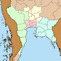
While the provinces are the top-level administrative subdivision, using larger scale regions especially for statistical purposes is very common. The most common way to divide the country is four regions - North, North-East, Central and South. These regions each have a different geography, the mountainous north, the low river plain of the central, the higher and dryer plateau of the northeast, and the long Malay peninsula. However the boundaries of these regions are not always so clearly defined.

Wolf Donner in the foreword of his 1978 geography monograph "The Five Faces of Thailand" writes
Unfortunately, the definition of "regions", a very important feature in economic geography, has not found mutual agreement between the National Statistical Office (N.S.O.) and the Ministry of Agriculture. The latter confined the North Region to the seven actually mountainous changwats of the north ("Far North"), whereas the N.S.O. included fifteen changwats in the North Region ("Greater North") with obvious effect on the size of the Central Region.
and in the note attached to these two sentences
This required much re-calculation when using data from different sources; but the region of reference was not always clear. Confusion became complete when the Ministry of Agriculture and Cooperatives published Agricultural Statistics of Thailand, Crop year 1972/73 in 1974. The former regions (with numbers of changwats) North (7), Central (35), North-East (15) and South (14) had been changed into North (16), North-East (16), Central (9), East (8), West (8) and South (14)...

Subregions of the central as defined by Wolf DonnerThe National Statistical Office (NSO) in its 2000 census still uses the same four regions as they were mentioned by Wolf Donner, who was then probably referring mostly to the 1970 census. As the central region in this definition is quite big, it can make sense to subdivide this into the west, east and the central proper, thus making it seven regions altogether. In another book by Wolf Donner, this time in German, he subdivides the central into four subregions, the central proper into the Bangkok Metropolis including the provinces surrounding Bangkok, and a region he named "sub-central". However, his definition differs from the one used in the Thai Wikipedia, which includes Tak (normally a northern province), while Dr. Donner includes Suphanburi and Samut Songkhram.

I don't know whether the NSO will continue to use the four regions in their forthcoming census in 2010, but according to a Thai wikipedian the Ministry of Interior nowadays uses the seven regions, but not being able to read all the MOI publications I could not verify this yet, nor be able to confirm the exact outline of these regions.

Another regional outline was mentioned in the 2Bangkok forum, according to Khun Wisarut it had 9 regions (Phak, ภาค) as the continuation of the Monthon in the years 1934 till 1956. But unlike the Monthon these much less powerful, that's probably why they are almost unknown nowadays. Any further information on these regions would be very welcome.