Friday, October 31, 2008

Districts in Surat Thani before 1917

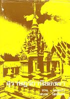
Cover of book Surat Thani Khon Rau
I have one book specifically on Surat Thani province, which my mother-in-law found me some years ago after being disappointed with what was available in the web.I haven't asked her where she found it, but it quite obviously was a used book, the cover already torn a bit, and it has some notes and underlining in the text. And it was printed on rather cheap paper, as it is now already quite brownish. The book is titled สุราษฎร์ธานีของเรา (Our Surat Thani) and written by ชวน เพชรแก้ว and สบาย ไสยรินทร์, it was published by the Teacher College of Surat Thani (วิทยาลัยครูสุราษฎร์ธานี, สุราษฎร์ธานี) in 1994.

As my Thai is still not good, I just browsed through the book so far and tried my luck on reading only for the part I am most interested - the history of the province, how the Mueang in the area were changed into the single province with its districts. To come to my point, the book contains a list of 11 districts in the province, but only dated as being during the reign of King Rama VI, that means before 1910. It is thus an older list than the one I have found in the Royal Gazette, which dates from 1917.

So below is the list of these 11 districts, together with their names in 1917 and today.
  • เมือง (Mueang), in 1917 renamed บ้านดอน (Ban Don) was renamed to Mueang and later into Mueang Surat Thani
  • พุมเรียง (Phumriang), in 1917 named เมืองไชยา (Mueang Chaiya) in 1917, and simply Chiaya today. This was the old center of the province at the coastal village Phum Riang.
  • เกาะ (Ko) - this should be the one named เกาะสมุย (Ko Samui) in 1917. Maybe this old named, which simply means island, was chosen because the district covered all the islands off the coast.
  • คีรีรัฐนิคม (Khiri Rat Nikhom), in 1917 renamed to ท่าขนอน (Tha Khanon) and today it has its historical name again.
  • พุมดวง (Phum Duang), renamed to ท่าโรงช้าง (Tha Rong Chang) in 1917. Was included into Phunphin later.
  • พุนพิน (Phunphin), same-named as today and in 1917, yet it was named ท่าข้าม (Tha Kham) in the meantime as well.
  • กาญจนดิษฐ์ (Kanchanadit), same-named in 1917 and today.
  • ประสงค์ (Prasong), downgraded to a minor district which is missing in the 1917 list though it was abolished in 1919. It was recreated as ท่าชนะ (Tha Chana) in 1948.
  • พระแสง (Phrasaeng), same in 1917 and today.
  • ลำพูน (Lamphun), in 1917 renamed to บ้านนา (Ban Na) and now named Ban Na San.
  • พนม (Phanom), same as in 1917 and today, except that it was downgraded to a minor district 1910 till 1971.
As Tha Chang created in 1908 is missing, but Lamphun, Phrasaeng and Phanom are listed which were transferred from Nakhon Si Thammarat in 1906, it dates the above table much better than the 5th reign quoted in the book.

The book continues to list 12 districts in the 6th reign - the changes to the one above are Mueang named Chaiya, Ko named Ko Samui, Prasaeng, Phanom and the new Tha Chana as minor districts. Then it lists 10 districts in 1937 (abolish of Phum Duang and Prasong), 11 in 1948 (creation of Tha Chana), and finally the 19 as of 1994, which is the same as today.

While for most of the district changes I have found the corresponding announcements in the Royal Gazette, especially the name changes and the abolishing of Phum Duang I cannot date yet.

Thursday, October 30, 2008

Emblem of TAO San Pu Loei, Doi Saket, Chiang Mai

Seal of TAO San Pu Loei, Doi Saket, Chiang Mai
By same random googleing I came across the website of the subdistrict municipality San Pu Loei (เทศบาลตําบลสันปูเลย) in Doi Saket district, Chiang Mai. While the website has nothing special - only a small part is available in English, but at least it has an English section, normally the websites of the municipalities or TAO are exclusively in Thai.

But what caught my attention was the emblem of the municipality, which unlike most municipal emblems does not show a geographic or historic speciality of the town, but a rather simple graphic. As it is such a simple design, I played with inkscape a bit and made it into a vector graphic, and it came quite close to the one seen on the website.

The emblem shows two hands holding a circle with the three letters อ (Oh Ang), บ (Bo Baimai) and ต (To Tao) - the Thai abbreviation O.Bo.To. which stands for องค์การบริหารส่วนตำบล (Ong Kan Borihan Suan Tambon), in English called Tambon (Subdistrict) Administrative Organization (TAO or SAO). The text in the top arc is องค์การบริหารส่วนตำบลสันปูเลย - TAO San Pu Loei, and in the bottom arc the name of district and province. Though most won't notice, similar calligraphic Thai letters are very commonly seen in Thailand - several of the Royal emblems have the letters Pho Po Ro in middle, the initials of HM the King.

But the work to redraw that emblem was rather in vain, because the TAO has already been upgraded to a subdistrict municipality this summer, and therefore they need to create a new emblem - not only the text in the upper half has to change, but the three letters in the middle have to change. That won't be that easy, as there's no common abbreviation for thesaban tambon (subdistrict municipality), though I rarely have seen ต.ต. used for it. So at least for the center of the emblem they have to come up with a completely new design.

Wednesday, October 29, 2008

Leaders of the administrative entities

In my Thai language class we came across the question on how to translate the term "mayor" (actually, the German "Bürgermeister") to Thai. While I suggested simply นายกเทศบาล (nayok thesaban), the dictionary said นายกเทศมนตรี (nayok thesamontri). So this made me create the following list of the names for the leaders of the various administrative entities in Thai and the recommended English translation as far as I found one.
Nayok O.Bo.To.
Central administrative units
Provinceผู้ว่าราชการจังหวัดPhu Wa Ratchakan ChangwatProvince governor
DistrictนายอำเภอNai AmphoeDistrict (chief) officer
Minor districtหัวหน้ากิ่งอำเภอHua Na King AmphoeMinor District (chief) officer
SubdistrictกำนันKamnanSubdistrict headman
Villageผู้ใหญ่บ้านPhu Yai BanVillage headman

Local administrative units
Municipality นายกเทศมนตรีNayok ThesamontriMayor
TAOนายกองค์การบริหารส่วนตำบลPresident of TAO
PAOนายกองค์การบริหารส่วนจังหวัดNayok O.Bo.Cho.Chairman of PAO

Tuesday, October 28, 2008

The Muang conspiracy

There's a new political blog I only discovered because the author has made his readership of my blog public. Named "The Muang Conspiracy" it won't be on the current political chaos in Thailand, or commenting news on other current issues, but instead the author intends to post and discuss radical political ideas.

One of the ideas he already presented is to implement more decentralization, not just at the grassroot level as it is now with the TAO and municipalities, but also on a regional level by resurrecting the Monthon. Basically the same which was suggested some time ago by Khun Wisarut in the 2bangkok forum. But recalling how harsh PM Samak silenced his Interior Minister in January when he thought loudly solving the insurgency in the Pattani region by giving the area a regional autonomy it seems the current national politicians are not willing to give away any power (or might I say chances to grab money by corruption) to regions.

Monday, October 27, 2008

Strange subdistrict geocodes

The geocode list contains several codes which unlike the normal geocodes do not start from 1, but instead from 99 and counting down. All of these are marked with an asterisk, so they are obsolete codes. It seems these are only found for subdistricts in districts, which were split off from a larger district in the 1970s. For example, the four subdistricts of Kho Wang in Yasothon Province each have one additional geocode. As the geocode for the district Kho Wang is 3507, each of the subdistricts has a number starting with 3507.

ฟ้าห่วนFa Huan3507010035069900
กุดน้ำใสKut Nam Sai3507020035069800
น้ำอ้อมNam Om3507030035069700
ค้อวังKho Wang3507040035069600

The additional codes starting with 3506 would be geocodes of these subdistricts while they still belonged to Maha Chana Chai (which has the code 3506) - the minor district Kho Wang was established in 1975 (Gazette).

That would be a good explanation for these codes, but there is one problem - in several cases these codes are wrongly assigned. Sometimes not all the original subdistricts of a new minor district have such an obsolete geocodes, but even more striking is the other way round. If reading the announcement of the creation of Kho Wang, one notices that only three subdistricts were split off; the fourth subdistrict named Kho Wang was in fact created in 1979 (Gazette). Thus, in fact this subdistrict was never part of Maha Chana Chai, and therefore should never have had a geocode starting with 3506.

Another example - Kap Choeng district, Surin, was created in 1975 consisting of the subdistricts Kap Choeng and Bakdai taken from the district Prasat (Gazette). However, the subdistricts Khu Tan and Dan, which were reassigned to this district from Sangkha district in 1977 (Gazette), both have two such obsolete geocodes, one for Sangkha district and one for Prasat district, even they never were part of Prasat. However the subdistrict Khok Klang created in 1976 (Gazette) does not have any such an obsolete geocode at all.

So I can only guess that these codes were an attempt to extend the geocode system into the 1970s, but while assigning the codes quite often mistakes like the above were made. And not only when there were these codes there were mistakes, there are also districts which were created in the 1970s but don't have such obsolete codes. Too bad I can only make my guesses from the numbers and the historical facts, I would love to know more on what is really behind these (and other) strange geocodes.

Friday, October 24, 2008

Provincial badges of Thai Scouts

Scout emblem of Surat Thani
On the website ThaiScouting, one of the many high-quality websites made by or under supervision of Richard Barrow at the Sriwittayapaknam School in Samut Prakan, it has two pages which depict badges worn at the back of the scarfs of the scouts. Every province has its own badge (ตราผ้าผูกคอลูกเสือประจำจังหวัด), which is most cases uses the same symbol which is also present in the provincial seal. For example the one of Surat Thani shows the chedi of Wat Phra Borom That, which is also the central symbol of the provincial emblem.

The first page displays the badges of the central, south and western provinces, the second one those of the north, northeast and eastern province. Also notice that there are a total of 12 groups of badges, making up yet another regional subdivision.

There are a few cases where the badge shows a different symbol than the provincial seal - hopefully I catched them all. While for the seals I know the explanation of each symbol (thanks to yet another website of the Paknam school), I have no idea about the alternative symbols yet.
  • Phuket - the seal shows the two heroines Thao Thep Kasattri and Thao Sri Sunthon, who saved the island at a Burmese invasion in 1785. The badge however shows a hill which emits light at the top.
  • Narathiwat - the seal shows a boat with a white elephant on the sail, commemorating a white elephant once caught in province. The badge shows a forest instead.
  • Ratchaburi - the seal shows royal shoes, the badge shows a hill surrounded by a snake.
  • Uthai Thani - the seal shows a pavilion at Wat Khao Sakaekrang, the badge a landscape.
Scout flag of Monthon Nakhon Si Thammarat
There were also historical flags for each regional troop. According to Flags Of The World, there was one regional troop in each Monthon, and even more interesting, in many cases the current seals of the central provinces of each Monthon followed the symbol previously used on the regional scout troop flag. For example the one of Monthon Nakhon Si Thammarat depicted shows the conch shell, which is now the symbol on the seal of Songkhla. 1896/97 the Monthon administration was located in Songkhla. To bad I cannot read enough Thai yet, as I own a book on Thai flags which also features these flags, but I cannot check if the above is confirmed by the author. But I'll investigate further and will write about it again when I have more.

Thursday, October 23, 2008

Happy birthday Blog

Today this blog celebrates it's first anniversary, and surprisingly I haven't quickly run out of topics to write about but instead found several new interesting things while researching for postings, always having several new postings almost ready for publication. I am now well above 200 postings, and have a posting nearly every day, while in the beginning I thought once a week would be a lot already. Sadly I did not (yet) succeed with my prime objective of this blog - getting feedback on those things I have run into problems, or maybe even find a insider contact able and willing to explain me things about the administrative structure. But in the access statistics I can see that occasionally Google brings someone to this blog who then spends quite some time reading several pages, and though hardly any reader gives any feedback I guess that what I put here has actually helped a few people researching these rather specific topics. And sometimes the search requests which led those readers to my blog give me ideas for new postings.

I can only invite every reader to give me feedback, a simple "Thank you, exactly what I searched for", or "can you explain more on ..." are welcome already, but of course comments like "... is wrong, correct would be ..." or even a "I can answer the question you raised, it is ..." would be the best. If you have topics I haven't written about but you think would fit into this blog, I am always open for your suggestions, often researching something which looks trivial at first turns out to yield a lot of interesting new stuff with time. If you don't like to do a public comment, you can always email me as well (the address is on my blogger profile). Or just click on the rating stars, so I know which topics or postings I should do more. Also, other bloggers referring to me giving my blog a higher authority in technorati are welcome, as well as other links for a higher Google rank.

Though I doubt there'd be anyone, but in case you are a programmer, or you are able to write XML and read some Thai, I can always use help in the coding project, which among other things should finally make it possible to easily access all announcements relevant to a specific entity.

Of course I am also curious who my regular readers are, and especially why they follow a blog on such a technical topic. From the access statistics I can estimate that there are around 10 to 20 regular readers using their web browser, and another 20 reading the RSS feed directly. If you have an account of blogspot, you can also become a follower of this blog, making your readership public.

Wednesday, October 22, 2008

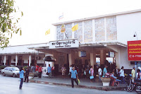
District office of Phunphin

Surat Thani trainstation
The Phunphin district (อำเภอพุนพิน) with its central town Tha Kham (เทศบาลเมืองท่าข้าม) is the transportation hub of Surat Thani province, especially as the southern railway passes through this town and not the city Surat Thani itself - that is located about 15km to the east. Also the main road from north to south through the province, national highway 41, passes near Tha Kham and not through the provincial capital. Surat Thani airport is also located near Tha Kham. Thus quite a lot of tourists taking the more budget way to go to Ko Samui will pass Tha Kham instead of Surat Thani city.

Tha Kham municipal administration officeThe administrative offices of the district and the municipality are located close together, and both not far from the train station. While the district office is of the standard style of these offices, the municipal office is a very plain office building. I even at first misidentified that office with the hospital next to it, which from the satellite image looked much more representative.

The municipality was created in 1955 as a sanitary district, and was upgraded to a subdistrict municipality in 1986. In 2000 it finally received the town status (thesaban mueang), which it still has today.

Phunphin district officeThe district Phunphin was one of the original ones of the province. The southern part of the district was at first a separate one named Phum Duang (พุมดวง) before 1917 and then Tha Rong Chang (ท่าโรงช้าง), and was merged into Phunphin someday between 1917 and 1938 - sadly I haven't yet found the relevant Gazette announcement on this. The only thing on the history of the district I could find in the Gazette archive was its rename from Tha Kham to Phunphin in 1939 (Gazette), however according to the district list of 1917 it was named Phunphin, so I am lacking another name change announcement.

Tuesday, October 21, 2008

Provincial governor reshuffle

Despite all the current political chaos in Thailand, the annual reshuffle of the administrative posts was done as usual effective October 1st, the start of the new fiscal year. So far I only know that the governor of Chanthaburi, Prajuck Suvarnapakdee (ประจักษ์ สุวรรณภักดี), was reassigned to Nakhon Ratchasima, as that was changed in Wikipedia just recently.

There also was an additional reshuffle of 13 provincial governors in spring, so by now both my own lists as well as the Wikipedia articles are probably out of date. Too bad the list at the Ministry of Interior, the only complete list I know wasn't updated. It even does not include the changes from April, as it still lists Chet Thanawat (เจตน์ ธนวัตน์) as the governor of Nakhon Nayok, but he was promoted to the more prestigious Khon Kaen province according to that news report. Many provinces on their own webpage have lists or at least the CV of the current governor, but it is much more work to compile such a list from 75 websites. So, any better source for a complete list is welcome.

Monday, October 20, 2008

When was the DOPA geocode system introduced?

From the district creations I earlier suspected that the geocode system was started in the early 1980s, and working through the subdistricts a similar timing seems to fit. Though often even the subdistricts created in the 1970s still have their geocode in th chronological order, all those created since the early 1980s are in that order.

There are a few odd cases however which would only be explainable if the system was in fact adopted several years later, and they tried to have the chronological order back for several years. But this wasn't done without mistakes, so the chronological order only fits in most cases.

Wat Phra Samut ChediMaybe the most striking evidence that the system is younger comes from the district Phra Samut Chedi, the southwestern district of Samut Prakan. This district was created in 1984, with five subdistricts split off from Mueang Samut Prakan district (Gazette). All except one of these five subdistrict has an obsolete geocode which it had when they were still part of Mueang district. But not the subdistrict Ban Khlong Suan, which was created in 1979 well before the new district was formed (Gazette). Thus if the geocode system was already in full use in 1984, this subdistrict must have had a geocode starting with 1101. The codes starting with 1101 only have four holes, and there are subdistricts created in Mueang district after the creation of Phra Samut Chedi, so the geocode for Ban Khlong Suan must have been completely forgotten.

Another proof that it was not yet in use in 1983 is the creation of the subdistrict Mueang Ka Rung, Ban Rai, Uthai Thani (Gazette), which has the code 610606, though the number 610607 belongs to a subdistrict Kaen Makrut created in 1917 and 610609 to one created in 1982 - don't know what happened with the 610608, that's one of the missing geocodes.

Another one from the districts: when Khao Kho was split from Lom Sak in 1984 in Phetchabun Province (Gazette), there were no subdistrict geocodes for the five subdistricts while they were still in Lom Sak.

So the DOPA geocodes were introduced after 1984, but for some provinces retrospect geocodes were also created.

Friday, October 17, 2008

Abolish and recreation of subdistricts in Uttaradit

In 1973 something special happened within the district Tha Pla, three subdistricts were abolished effective December 18 (Gazette), and effective on the same day three new subdistricts were established taking the names of the three abolished subdistricts (Gazette).

The three subdistricts affected are
  • Tha Pla (ท่าปลา), the 3 muban of the old subdistrict were added to Pha Lueat
  • Hat La (หาดล้า), the 3 muban of the old subdistrict were added to Nam Man
  • Charim (จริม), the 2 muban of the old subdistrict were added to Tha Faek
The new subdistricts were all split off from Nam Man, and each contained about 10 muban.

Also in 1970, the sanitary district Tha Pla was abolished (Gazette), and a new sanitary district with the same name was established on November 20 1973 (Gazette) - I mentioned this earlier as one of the former municipal areas.

Looking at a map gives the explanation for this - the Sirikit reservoir which was completed in 1973 and thus its area of 220 km² drowned most of the area of those three original subdistricts as well as the sanitary district as the old central town of the district. By the end of 1973 the settlements in those three subdistricts must have been moved already - thus they only consisted of so few muban. Maybe most of the population was moved to the area of Nam Man, and the newly created subdistricts then mainly consisted of the original communities relocated there.

Thursday, October 16, 2008

Provincial emblem stamp series, part 3

The third issue of the stamp series with the provincial emblems was published on October 10, this time featuring the emblems of the 10 provinces Pattani, Phra Nakhon Si Ayutthaya, Phang-nga, Phatthalung, Phayao, Phichit, Phitsanulok, Phetchaburi, Phetchabun and Phrae. According to SiamStamp, this issue #856 has a circulation of 900,000 sheets, and 15,000 first day covers. The design of the stamps was done by Udorn Niyomtham of the Thai post, and was printed in the Netherlands. The first day covers should show up on the FDC blog soon as well.

As each issue contains 10 emblems (except the first when they did two sheets at the same time), now 40 out of 76 emblems are covered, and there should be another 4 issues forthcoming - the next should then be in April next year.

Wednesday, October 15, 2008

Census of 1904

As it was recommended at the New Mandala blog, I got myself the book Creating Laos and am currently reading it. While obviously most of the content is off-topic for this blog, I have just came across an interesting bit on the first national census in Siam in the year 1904. For the author the main point is that there was no distinction between a Lao and a Thai ethnicity in this census, while Mon and Khmer were counted separately according to their language, and the Chinese according to the traditional pigtail hairstyle for men and the clothing for women. Those ethnic Chinese who already adopted Thai clothing or hairstyle were instead counted as Thai.

I did not know about this census before - both statoids.com as well as the underlying book start with the 1947 census, and also the National Statistics Office claims the 1909 census as being the first. This is probably due to the fact that in 1904 the census was only done in some parts of the country - central parts of Siam excluding Bangkok and the outlying areas of the Isan and the North (Lan Na), this it wasn't a nationwide census.

The whole section is based on the paper An early Thai census: translation and analysis by Volker Grabowsky. If someone could provide me with a scan of this 91 page long paper it'd be great.

Tuesday, October 14, 2008

Historical photo of a province hall

I found the photo below in the book "History of Lanna" by Saratsawadi Ongsakun, a great resource on the history of northern Thailand.

The photo shows a province hall sometime around 1900, when the provinces were still named Mueang instead of Changwat. The sign over the entrance reads ที่ว่าการเมือง (Thiwagan Mueang), a name now only used for the district offices which are called Thiwagan Amphoe. The provincial administration building today is named Sala Klang instead. Sadly neither that sign nor the caption of the photo give any further details on which provincial administration is pictured, even the timing of the photo is very unclear as it only says it was taken between 1897 and 1917. The photo is from the National Archive, but there seems to be no easy way to browse that archive like it has for the Royal Gazette.

The office looks quite different from those of today, like those few I have published the photographs already. Some additional ones can be found at Wikimedia Commons. As such administrative buildings aren't usually photographed by tourists, and it will take me many years to visit all provinces, or even all districts, I can only invite everyone to take such photos and make them public under a free license, to have more illustration on the Wikipedia articles. Also any pointer to historical photos like the one above would be welcome, especially if the copyright for that photo has expired already and it would be possible to use it as well.

Monday, October 13, 2008

Aborted district creations

I mentioned them earlier, there are geocodes already assigned for districts which are not yet existing. I am listing those for Phitsanulok below. Unlike that subdistrict geocode, these codes weren't listed in any of the files on the DOPA website.
  • 6510: Sap Phrai Wan (กิ่งอำเภอทรัพย์ไพรวัลย์) or Kaeng Sopha (กิ่งอำเภอแก่งโสภา), split from Wang Thong
  • 6511: Wang Khong (กิ่งอำเภอวงฆ้อง) or Nong Tom (กิ่งอำเภอหนองตม), to be split from Phrom Phiram
  • 6512: Nikhom Nong Kula (กิ่งอำเภอนิคมหนองกุลา) split from Bang Rakam
  • 6513: Wang Nam Khu (กิ่งอำเภอวังน้ำคู้), split from Mueang Phitsanulok
  • 6514: Nakhon Bang Yang (กิ่งอำเภอนครบางยาง), split from Nakhon Thai
An old webboard posting on the website of the provincial administration of Phitsanulok sheds some light on these (and the other 79 such district codes). The posting is titled "Creation of 5 minor districts in Phitsanulok quietly abandoned", and the author asks what happened with the 5 planned minor districts planned before the Baht crisis of 1992 (maybe the author meant the Asian financial crisis of 1997 instead), and says that these were stopped due to budget reasons and other reasons yet unknown to him. Sadly noone answered him with an explanation, but the budget reasons fit with my guess what there were (almost) no new districts and subdistricts since 1997.

Friday, October 10, 2008

Names of newly created Muban

Other than originally planned I already processed the announcements on the creation of muban since 2003. While working through them, I have notice some interesting small facts on the naming of these entities.

As mentioned before, the names of muban are not unique, quite often one settlement is divided into several muban all sharing the same name. So it is not surprising that for the muban created in the last 5 years quite a lot of the new one inherited the name of the muban they are split off from. But instead of always having exactly the same name, quite often the new muban gets a suffix attached. The ones easy to understand are Nuea (เหนือ) meaning North and Tai (ใต้) meaning South for areas in the north or south of the settlement. However east or west are by far less common. Instead another common suffix is Phatthana (พัฒนา) meaning development, maybe this one is used for newly developed residential areas.

Thanks to summarizing the content of the announcements in XML, it was just a little bit of programming to have these numbers calculated, and I can update them anytime new announcements get published. Since 2003 there had been 841 announcements, creating 1966 new muban. Out of these, 352 received the same name as the parent muban, 59 with the suffix Nuea, 52 with Tai, and 77 with Phatthana. Less frequent suffices are Mai (New, ใหม่, 36 times), Samakhi (Unity, สามัคคี, 12 times), Thong (Gold, ทอง, 10 times) or a number (9 times). Mai also shows up as a prefix 28 times. There are only 5 times with the postfix Tawan Ook (ตะวันออก, East) and a single one with Tawan Tok (ตะวันตก, West). The province with most new muban in these years was Nakhon Ratchasima with a total of 144.

Finally, here are examples for each of the main cases:
  • Village 10 of Saraphi, Saraphi, Chiang Mai is named Ban Pak Kong (บ้านปากกอง) and was split off from village 5 with the same name in 2004. [Gazette]
  • Village 18 of Ta Lang Nai, Wang Nam Yen, Sa Kaeo is named Ban Non Thong Phatthana (บ้านโนนทองพัฒนา) and was split off from village 9 named Ban Non Thong (บ้านโนนทอง) in 2005. [Gazette]
  • Village 13 of San Sali, Wiang Pa Pao, Chiang Rai is named Ban Pong Nok Nuea (บ้านโป่งนกเหนือ) and was split off from village 6 with the name Ban Pong Nok (บ้านโป่งนก) in 2006. [Gazette]
  • Village 14 of Sop Prap, Sop Prap, Lampang is named Ban Sop Prap Tai (บ้านสบปราบใต้) and was split off from village 2 with the name Ban Sop Prap (บ้านสบปราบ) in 2006. [Gazette]
  • And finally a case which is not covered in the statistics above - village 8 of Dan Mae Kham Man, Laplae, Uttaradit is named Dan Mae Kham Man Phatthana (บ้านด่านแม่คำมันพัฒนา) and was split off from village 1 named Dan Mae Kham Man Nuea (บ้านด่านแม่คำมันเหนือ) in 2003. [Gazette]

Wednesday, October 8, 2008

A planned subdistrict in Phitsanulok?

The file titled ccaatt by the Department of Provincial Administration (DOPA) contains all of the geocodes for the central government entites - provinces, districts and subdistricts. There are also some obsolete codes marked with an asterisk, and also several strange ones I am still not sure about.

But there is also one very strange one in this list, which gives the number 65080000 to the subdistrict Khok Laem (ตำบลโคกแหลม), Noen Maprang district, Phitsanulok province. Though it is not marked as obsolete, there is no such subdistrict, Noen Maprang has just 8 subdistricts in all other sources. The entry in the geocode list is already found in the oldest version of this list I could find with archive.org back from 2001, when DOPA was still named DOLA (Department of Local Administration). This subdistrict shows in none of the populations statistics from DOPA, nor was there any announcement in the Royal Gazette on it. The previous code 65070000 belongs to the subdistrict Wang Yang created in 1984, which gives only a very rough earliest date for the assignment of that odd geocode.

So I can only guess that this is (or was) a planned district which already got a geocode assigned yet wasn't created, and DOPA forgot to mark this entry with the asterisk as a special code or remove it from their list altogether. As there are similar codes for districts its a pity this seems to be only such subdistrict code which still can be found.

Tuesday, October 7, 2008

Boundary districts of the year

Thanks to my RSS feeds of the DOPA announcements I can report on the annual award given to the best boundary districts. The original announcement 43/2008 is of course completely in Thai, so I hope I did not misunderstand it too much in my summary.

The awarding of the most efficient districts on the boundaries to the neighboring countries follows a program aimed at improving the stability at the boundaries running from 2007 till 2011. The four winning districts were announced by the director-general Mr. Wichai Sikhwan (วิชัย ศรีขวัญ) of the Department of Provincial Administration last Thursday.
  1. Chai Prakan (อำเภอไชยปราการ). Chiang Mai province, at the boundary to the Union of Myanmar
  2. Phon Phisai (อำเภอโพนพิสัย), Nong Khai province, at the boundary to Laos
  3. Phu Sing (อำเภอภูสิงห์), Si Sa Ket province, at the boundary to Cambodia
  4. Betong (อำเภอเบตง), Yala province, at the boundary to Malaysia
I don't know whether it is a coincidence or intentionally that for each of the neighboring country one district was selected. In fact this announcement was the first time I have heard about this program, but as awards are very popular in Thailand it is not the only program to reward officers or offices for outstanding performance. Earlier I have seen one awarding the best district officers, and if I recall correctly there were calls for nomination of outstanding subdistrict headmen as well.

Monday, October 6, 2008

Bangkok gubernatorial election results

Yesterday the elections for the new governor of Bangkok took place. I listed the list of all 16 candidates earlier, but as anticipated most of them had absolutely no chance.

Bangkok Post gives the unofficial results as follows
  1. Apirak Kosayodhin, 991,018 votes, 45.9%
  2. Prapat Chongsa-nguan, 543,488 votes, 25.2%
  3. Chuwit Kamolvisit, 340,616 votes, 15.8%
  4. Kriangsak Charoenwongsak, 260,051 votes, 12.1%
  5. Leena Jungjanja, 6,267 votes, 0.3%
For the exotic candidates, the Wikipedia article on the elections has the complete numbers. Yet there is still one complaint to be decided by the Election Commission, which was filed by Chuwit on billboards erected by the Bangkok Metropolitan Authority and which he saw as supporting Apiraks election campaign. Chuwits billboards and posters are the most interesting ones anyway, so no wonder they get featured on the satirical Not the Nation.

For a short history of the governors of Bangkok this forum post at 2bangkok gives the complete list of appointed and elected governors since the merger of the provinces Phra Nakhon and Thonburi to the Bangkok Metropolis.

The election campaigns haven't made much news in the English language press, probably due to the comfortable lead of Apirak in all the polls. Only Chuwit hitting a journalist after a TV interview even made it into the German press - when I read about this incident one of my favorite quotes by Isaac Asimov came to my mind: Violence is the last refuge of the incompetent (from the book Foundation).

Leena's campaign was especially ill-fated. First she fell into the polluted Saen Saeb canal near Pratu Nam while campaigning (here's a video), and then the next day while she took a bath in another canal for a publicity stunt and one of her aides drowned.

Friday, October 3, 2008

Provincial symbol flowers and trees

Almost every province has two plants as their provincial symbols, one flower and one tree. In a few cases, flower and tree symbol are the same plant, for example Phatthalung has Shorea roxburghii for both. There are also a few provinces without a symbol flower, for example Krabi and Songkhla, but all provinces (including Bangkok) have a symbol tree.

The photo to the right shows one of two Yellow Flame Trees (Peltophorum pterocarpum) planted in front of the provincial hall of Nonthaburi, quite obviously because this is the provincial symbol tree for Nonthaburi.


I had compiled the complete list back when I researched to create the Wikipedia articles on the provinces, and the main sources were the province descriptions from the Ministry of Interior (the PDF files likes in the green box of this page), a list from panmai.com (flower and trees), and also somewhere in the TAT website. In most cases these sources all list the same plants, but in some cases there are problems, interestingly only for the trees. For example for Samut Songkhram most have Casuarina equisetifolia as the provincial tree, but the TAT listed Barringtonia asiatica instead. It is of course possible that a different tree has been assigned to the province lately and not all lists have been updated already. An authoritative list would of course be fine to settle the last doubts.

For most flowers and almost all of the tree I did not find any explanation on why that specific plant was chosen. But from the few where I know the rationale I am presenting four examples.
    Rafflesia kerrii
  • The provincial flower of Surat Thani is the Rafflesia, which is an obvious choice since this flower is the most extraordinary flower of all Thailand, and is found most often and easily accessible in this province. I first heard about this flower when I researched that province article, but it took me some years till I was able to see one in nature.
  • The provincial flower for Ubon Ratchathani is the lotus (Nymphaea lotus), which is also quite clear as Ubon means Lotus. Just not sure if it is in Sanskrit or on Pali, the languages which are the origin of many ceremonial names are words in Thailand.
  • Another obvious choice is the Siam Tulip (Curcuma alismatifolia), the provincial flower for Chaiyaphum. I visited the Siam Tulip fields in Pa Hin Ngam national park in this province, which is clearly one of the attraction of this province.
  • The provincial tree of Chumphon is the cluster fig (Ficus glomerata). The Thai name of this tree is Maduea Chumphon (มะเดื่อชุมพร), and it is one of the possible explanation for the origin of the name of the province.
Wherever I found the explanation for the specific choice I added it into the Wikipedia article, so if you know any not covered there yet I'd love to hear about them.

Thursday, October 2, 2008

Time between Gazette announcement approval and publication

The earlier case of a Royal Gazette announcement apparently published before it was approved made me program a little statistics to check the time elapsed between the date of approval and publication in those announcements in my XML. Besides this helped me to find a few entries where I mistyped one of the dates, I also confirmed the above mentioned case was the only one so far out of 3500 announcements I have processed already.

As a mean value, 42.7 days elapse between the date it is signed for approval and it is published in the Gazette; yet most often it's exactly three weeks between the two dates. The longest times elapse for municipal announcements,with the upgrade of subdistrict municipality Sattahib to a town taking almost one year (Volume 124, Issue พิเศษ 184 ง, Page 2). It was signed on December 12 2006, published on November 26 2007, and took into effect on January 12 2007. Also, the creation of subdistrict municipality Prasat Thong took 360 days.

Wednesday, October 1, 2008

Highest number of Muban ever?

While working through the older subdistrict creations, I have run across a case where the number of muban was by far higher than in all the cases I have found before. The subdistrict Tak Fa (ตากฟ้า) was created in 1961 containing just 5 muban. However just 6 years later, 4 new subdistricts were split off from Tak Fa, each containing 10 muban, and the villages 1 to 12 stayed with Tak Fa. Thus in these 6 years the number of villages increased to the tenfold (Announcement), altogether the subdistrict had 52 muban when it was split.

Amphoe.com has just a short history of the district Tak Fa.
อำเภอตากฟ้า เดิม อยู่ในเขตการปกครองของอำเภอตาคลี จังหวัดนครสวรรค์ พื้นที่เป็นป่าดงดิบ มี สัตว์ป่าชุกชุมมาก พ.ศ. 2496 ทางราชการได้ตัดถนนพหลโยธินผ่าน โดยแยกออก จากอำเภอตาคลี โดยจัดตั้งเป็นกิ่งอำเภอตากฟ้า เมื่อวันที่ 13 ตุลาคม 2513
Which translates to
District Tak Fa originally belonged to Takhli district, Nakhon Sawan province. It was an area covered with jungle and with plenty of wild animals. In 1953 the government build the Phahonyothin highway. Because of this the minor district Tak Fa was split off from Thakli on October 13 1970.
In fact this is even not fully correct, as the district did not start as a minor district, but was created as a full district directly. The district then covered the area of the original subdistrict Tak Fa plus the subdistrict Udom Thanya which was also created in 1967 out of Hua Wai, altogether 6 subdistricts. Yet it does not give the full explanation of the rapid development of the area in the 1960s, as that main road was build several years before already. There must have been some more development programs, using the track of the highway as their starting point to convert the jungle into agricultural lands.