Thursday, December 30, 2010

amphoe.com is back

After nearly 3 months of downtime, the website amphoe.com has suddenly come back to life. When I last checked for it mid-December the nameserver was still not responding and thus the site inaccessible, but now yesterday it worked again. Thus apparently the administrator of the nameserver managed to switch it on again, and the website reappeared as nothing ever happened.

Thus the content is the same as before, most notable there are still no entries for the district Galyani Vadhana created one year ago, and even Wiang Kao created in 2006 is still not present. The names of the district officers are more up-to-date, yet the last reshuffle from January 2010 wasn't added yet - for Mueang Surat Thani district amphoe.com still lists Chonosak Wanitcharoen(ชลอศักดิ์ วาณิชย์เจริญ), who is now permanent secretary of Surat Thani province.

Now the site is still working again, maybe I should make a complete mirror for myself, as the next critical point will be the expiry of the domain registration on January 15 - hopefully this time the administrator does the extension early enough and the domain does not fall to a domain grabber. But even then, the site will still be there under the IP address 115.31.184.25 until the actual webserver will be switched off.

Tuesday, December 28, 2010

Om Noi upgraded to city municipality

Yesterday the upgrade of Om Noi town (เทศบาลเมืองอ้อมน้อย), Samut Sakhon province, to a city municipality (เทศบาลนครอ้อมน้อย) was announced in the Royal Gazette, making it the 27th city of Thailand. Same as the municipal announcements last week, this change isn't yet covered by the board meeting transcripts available online, thus was decided after mid-September. The announcement was signed on November 11, which I guess is also the date when the change is effective.

Sadly the announcement PDF does not include the map of the municipality - which is not only included in announcements on area changes, but also when the status is changed without any change of area. Without that map, I only relied on the website of Om Noi which only had a small sketch map, thus it took me some time to find their office in Google Earth.

Om Noi was originally a sanitary district, created in 1967 [Gazette]. In 1994 it was upgraded to a subdistrict municipality [Gazette], and in 2002 to a town municipality [Gazette]. While the sanitary district only covered part of the subdistrict Om Noi, apparently with the upgrade to a municipality the area was enlarged to cover the whole subdistrict.

Thursday, December 23, 2010

Municipal announcements from December 17

Last week, four changes for municipalities were announced in the Royal Gazette, which all took me by surprise as the board meeting transcript did not cover them - so they may have been decided in the board after September 9, which is the latest one currently available. It would fit, as usually the time between board meeting and announcement seems to be something around 3 month, except those cases where it takes way longer without apparent reason.

Wednesday, December 22, 2010

Sanitary districts 1905-1932

As mentioned before, chapter 7 of Thailand: The Modernization Of A Bureaucratic Polity by Fred W. Riggs contains a lot of interesting facts on the administrative subdivisions, so I start with quoting from there with the passage on the sanitary districts (sukhaphiban, สุขาภิบาล), when they where first created.
The first efforts to establish local self-government in Thailand were actually made under the absolute monarchy, long before the revolution of 1932. As early as 1905, an experiment in local self-government was launched with the creation of a sukahpibahn, or "sanitation district," in a commune of Samud Sakorn province, a short distance southwest of Bangkok. Provision was made for the creation of a board all of whose members were appointed ex officio, namely, the village headmen with the commune headman as chairman. (A number of villages or mu ban constitute a commune or tambon, whose head is chosen from among the headmen of the constituent villages.) This board was authorized to collect certain taxes, largely on houses and building construction, to be used for the maintenance of local public works, such as roads, bridges, and lights, and to enforce local sanitation rules in a congested coastal fishing area.

In 1908 and again in 1915, new acts were promulgated expanding the powers of the sukahpibahn, providing that similar boards could be established elsewhere on the recommendation of the provincial governor and the monthon (region) head. By the time of the recolution, it is estimated that there were some forty-five sukahpibahn.
The two acts mentioned are the 1908 sanitary district act and its 1916 amendment.

According to the Royal Gazette announcements, the sanitary districts created after the first one were
  • 1909: Nakhon Ratchasima, Chanthaburi, Songkhla
  • 1910: Phichai (i.e. Uttaradit), Nakhon Si Thammarat, Chonburi
  • 1911: Nakhon Pathom
  • 1912: Phuket
  • 1914: Chiang Mai
  • 1915: Phitsanulok, Ratchaburi, Photharam, Nakhon Sawan
  • 1916: Krung Kao (i.e. Ayutthaya), Song Phi Nong, Ban Pong
  • 1917: Samut Prakan, Saraburi, Lopburi, Prachinburi, Suphanburi, Nakhon Nayok
  • 1918: Singburi, Phichit, Trat, Rayong
  • 1928: Hat Yai
  • 1930: Surat Thani, Phetchaburi, Uthai Thani, Chum Saeng
  • 1931: Trang, Chachoengsao, Ban Mi
These 34 together with Samut Sakhon were all the originally created sanitary districts, as the 1935 Gazette announcement on the upgrade of sanitary districts to municipalities states that out of the 35 (and not 45) entities 32 become town municipalities, two become subdistrict municipalities and 1 (Chiang Mai) becomes a city. Sadly the other 34 sanitary districts are not listed by name in there.

Tuesday, December 21, 2010

License plate images for Chiang Rai and Saraburi

Last Friday, two new provincial license plate graphics were published in the Royal Gazette. Actually, only one is new, as for Saraburi I wasn't able to see any significant difference to an earlier one from 2006. For Chiang Rai, while some elements were reused, the graphic is different from the previous one announced in 2005.

The graphic for Saraburi [Gazette] shows the seal of the province in the middle placed on a large sunflower field. The main symbol of the seal is Wat Phra Phutthabat, the most important temple of the province. Both the temple as well as the sunflower fields are the major tourist attractions of the province. The graphic from 2006 is almost identical, only the colors are less intense.

The graphic for Chiang Rai [Gazette] is dominated by the Phu Chi Fa cliff, from where the sea of clouds can be seen at sunrise if weather allows, with the lower hills peeking through the morning mist. The tower to the left probably refers to Wat Rong Khun. the famous white temple built by renowned artist Chaloemchai Khositphiphat. However the yellow color - the temple is actually bright white - and the clock confuse me a bit. In the 2005 version, this tower wasn't present yet, and the cliff and clouds had a different design. The rising sun was omitted in the new graphic however.

Monday, December 20, 2010

New Google Earth imagery for Thailand

Since Google started to push new imagery to Google Earth twice a month I no longer reported on these updates here, as with the more frequent updates there often were only very few areas in Thailand which received an update, and I also did not want this blog to become just to be yet another Google Earth blog. However, the latest update last week was a really massive one, and not only in Thailand it seems they rolled out much more new data than usual.

Already when the inofficial Google Earth Blog reported the new imagery I noticed areas with new data - either because I could remember the area to have no hires yet, or because I noticed that there were district office locations I had not yet worked into my XML because I could not make out the building in the lores imagery. Most notably, these were parts of Phatthalung province (sadly not yet the town of Phatthalung itself), and an area east of Nan town. But with the official KML where Google marks all the updated areas I learned I found just a small portion of all the changes. In the boundary area to Myanmar in Tak province as well as in Rayong and Chanthaburi at the east coast I could finally get district office location very exact, which are now in my XML and my own KML of administrative offices.

As I mentioned Phatthalung before - while the new hires area comes short of covering the provincial capital, it covers the area between the town and the lake. And while browsing around there, I noticed that it has the old palace of the province governor in there, now yet another item on my long list of places I still want to visit in Thailand. This location also nicely confirms the history of Mueang district - in 1917 the district was renamed to Lampam, the subdistrict where this palace is located. In 1924 however the administration was moved westwards towards the newly built train station.

Friday, December 17, 2010

Ministry of Interior color scheme

In the list of commands from the Department of Provincial Administration (DOPA) to its subordinate offices I found one from November 18 titled การกำหนดสีสัญลักษณ์เพื่อเสริมสร้างภาพลักษณ์ของกรมการปกครอง (Definition of symbol colors for the Ministry of Interior). While the first pages of the PDF are scans, luckily the final pages contain real text and it was therefore possible to do a copy-and-paste to get a quick machine translation.

The two colors are a light blue (dodger blue) and yellow, or with their RGB values 1E90FF and FFFF00. Blue is the color for Friday, as the Ministry of Interior was created on Friday, April 1 1892. It also is the color of credibility, loyalty, coolness and peace, which are the maxims of the MOI. Yellow is of course well-known as the color of HM the King, who was born on a Monday; though this symbol of loyalty to the King has been turned into a political symbol by the PAD and now is no longer purely a royal symbol. Symbolically, the color is supposed to mean friendship, optimism, encourage life and creativity - which are the maxims of the DOPA offices.

More interesting than the symbolism of these colors are the actual orders within this document. This color scheme is supposed to be used in documents like brochures as well as in the various websites. Interestingly as one example amphoe.com is mentioned, even though that site has disappeared even before that document was published. Not sure if this means the disappearance of that site was accidentally and for two months nobody at DOPA noticed it - well, would not be too much surprising if recalling the protecttheking website disaster.

Other places where this color scheme is supposed to be adopted is at district offices, so if a reader happens to see some newly painted fences, flower pots, or other items around the district offices in these colors I'd like to hear - being away from Thailand most of the year I can hardly notice these minor changes myself.

Thursday, December 16, 2010

Thursday linkage

Old province hall of Ubon Ratchathani
Photo by Isantraveller
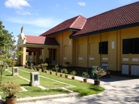
Isantraveller visit the Ubon Ratchathani National Museum, which is located in the historic province hall. That building, located right next to the city pillar shrine, was in use 1918 to 1968, until it was replaced with a new larger building close-by. The pages of the Fine Arts Department on this museum don't add much to the posting.

Though I haven't yet made it t Ubon Ratchathani myself - I only been to the Northeast once, and just made it to Phimai - I have created a small map with the main administrative buildings of the city. But since they are all located rather close together it's hard to miss any of them anyway.


View Ubon Ratchathani administration in a larger map

Wednesday, December 15, 2010

New font in Royal Gazette announcements

New font [Source]
Old font [Source]
Starting on last Monday, the PDFs from the Royal Gazette have changed their look a bit, as the font used in the documents has changed to a much more rounded one. This new font is Thai Sarabun PSK, which was created by the National Software Industry Promotion Agency as being the new standard font. It is also supposed to most close with the recommended font outline as defined by the Royal Institute, but also being royalty free open source and thus could be used without any copyright concerns. The previously used font Angsana UPC, one of the standard fonts from Microsoft Windows. The introduction of these fonts was decided by cabinet in September 2010.

The font can be downloaded from SIPA - however use that link with care, as apparently a spammer was already able to insert his malicious links at the top of the article. I cannot confirm if the install wasn't replaced with malware spreading one.

The biggest advantage of this new font is however that the PDFs now contain real Unicode text. With the previous font, it was almost Unicode, but some of the vowels and tone marks were using private Unicode characters, probably to make these characters be positioned correctly on the higher consonants. But then when copying the text to clipboard, or trying to let Google translate such a PDF completely, fails as then many words loose their vowels and the translation turns into glibbersh. But that was already an improvement to the very first full digitally PDFs found in the Royal Gazette website, as those were done with a Mac and had a 8bit codepage instead - making it almost impossible to get the Thai text into someting readable. For a little comparison see the following table:

Monday, December 13, 2010

Bueng Kan interpellation

When I was looking for any mention of จังหวัดบึงกาฬ (Bueng Kan province) on the website of the Thai parliament to see if the law on the creation of the province has been already discussed there, or has been at least scheduled, I instead found a document titled กระทู้ถามที่ ๑๑๘ ส. เรื่อง การจัดตั้งจังหวัดบึงกาฬ - interpellation 118 S. about creation of Bueng Kan province.

This interpellation dates from May 6 2010 - formulated by Thewarit Nikonthet (เทวฤทธิ์ นิกรเทศ), Member of Parliament from Nong Khai representing the Social Action Party - and unlike the interpellations I find in the Royal Gazette no official answer to the request is included, so it probably has been rendered obsolete by the decision of the cabinet in August.

But the one thing I now understood - probably obvious to any Thai used to the common acronyms and abbreviations - is that why those interpellations I find the Royal Gazette all have a number with the letter Rho Ruea (ร.) behind it. The letter simply indicates which of the institutions is addressed in the interpellation.
  • ร. stands for Government (รัฐบาล, Rattaban)
  • ส. stands for the House of Representatives, the Lower House of the Thai parliament (สภาผู้แทนราษฎร, Sapha Phu Thaen Ratsadon Thai)
  • ว. stands for the Senate, the Upper House (วุฒิสภาไทย, Wutthisapha Thai)
While there are some older interpellations for the Senate or the House of Representatives found in the Royal Gazette, all of the current ones are directed to the Government.

Friday, December 10, 2010

Mueang Phon Phisai in 1884

Another interesting quote from the book Isan Travels by Etienne Aymonier. On February 5 1884 he stayed in Phon Phisai, a small Mueang east of Nong Khai at the Mekong river, and gave a detailed description of this small province in his travelogue. I only have a few pages of this book at hand right now - will buy it next time I'm in Bangkok for sure - but it seems in other chapters it has similar descriptions of the Mueang he visited. As many of the minor Mueang are nowadays districts, this should give quite some material to enhance the history sections of the corresponding Wikipedia articles. The one on Phon Phisai also had almost nothing about the history prior to the 20th century.

Note that the coordinates given in the first sentence are clearly wrong as it would have placed Phon Phisai into Phrae province, Francis Garnier systematically had the longitude about 3 degrees off to the west maybe due to a faulty clock - the correct location of the modern district center is at 18°1′19″ N, 103°4′38″ E.

Mœuong Phon Vi Saï, at 18°01′00″ N, 100°39′00″ E (according to Garnier), was a village of about 150 huts dispersed among fruit trees along the right bank of the river. The terrain, quite low, flooded by the river's high rises, did not allow the cultivation of rice in that immediate vicinity. There were five pagodas, each with seven or eight monks. The population, which was Laotian, cultivated rice and cotton. There were a few Chinese there who sold fabric and pottery and who bought bastard cardamon, which could be collected in the forests. [...]

The chau had as titles: phrah saurinhah sakdi santhon chao Mœuong Phon Vi Saï; or, according to others phrah visaï saura dêt chau Mœuong Phon Vi Saï. The province was bordered in the east by Sayahbouri at the Keng Sadâk, a four days' march from Phon Vi Saï; in the south by Nong Han, in Ban Pho, half a day's march from Phon Vi Saï; and in the west by the Houé Luoung, which separated the province from Nong Khaï. In the north this small province, entirely on the right bank, was bordered by the Great River. Nevertheless, people said that Mœuong Pasoum on the Nam San came under the jurisdiction of Phon Vi Saï and still sent its tribute there. In Phon Vi Saï there reportedly were 900 registered men and 200 outside. The annual poll tax was six ticals per married registered man, three ticals for an elder, and two ticals for a single young man. The tribute taken to Bangkok was thirty-six catties. The inhabitants complained that the tax was too heavy. The authorities had requested a reduction from Bangkok, but in vain.

When my two men were in Phon Vi Saï, the chau had been dead for some time, leaving behind only young children. His first cousin, the oppahat, provisionally replaced him while waiting for his nomination as incumbent; the two dignities had been in the family for a long time. The dignities of ratsevong and ratsebout belonged to another family, which also passed from father to son. [...]

Wednesday, December 8, 2010

New municipality geocodes

When DOPA redesigned their website in spring this year, the pages which contain the population statistics were reset to the 2009 state, and also the last update of the geocode list was reverted. When I now took yet another look at the website, there was a link to the statistics, but not using the www.dopa.go.th server name but instead simply an IP address. To my surprise at that address it not only had the latest population statistics, but also the geocode list was there, and even this was even last updated in October. Thus it is interesting to compare the changes within the last year.

While the only change in main file, ccaatt containing the codes for Changwat, Amphoe, Tambon, are the codes for Galyani Vadhani district, the rcode file which contains the municipality codes is more interesting. Most of the changes in that are the deletion of the obsolete codes, for example those of the Sakha Tambon and a few municipality codes assigned but not used yet. Then there are upgrades of municipalities and name changes, yet the only really new ones are the following codes.
It's also interesting to look at how long it took from the creation of these municipalities until they were listed with a code. Krathum Lom dates from 2007, Thap Ma from 2009, and all others from 2008, so about 2 years until they assigned the code. Note that most of the other new municipalities created in the last 4 years have no code yet, and especially in the case of Nakhon Ratchasima and Chiang Mai there are not enough codes free for all of them.

I don't the reason why the codes aren't assigned directly when the municipality is created, yet my guess is that it receives a code once they have the municipal registration office running - this list is named RCode, so the R may stand for registration, and also in the DOPA population statistics most of the new municipalities don't show yet as well, so maybe the numbers are still those reported by the Amphoe registration office.

Tuesday, December 7, 2010

Municipal upgrades annoinced

End of November three status changes of municipalities were announced, two TAO to become subdistrict municipalities and one subdistrict municipality to become a town. All of them been mentioned in the board meetings earlier this year.

Friday, December 3, 2010

Provincial slogan for Bueng Kan

In a Thai blog I found one posting about the forthcoming Bueng Kan province, which started with the slogan of the province. As the province isn't yet created I am of course wondering if this slogan is already official - and actually, who creates these slogans anyway. For the symbols of the provinces I only guess that the emblems or seals are created by the Fine Arts Department, as that one also published books about them; I vaguely remember to have read that one tree was bestowed to a province by HM the Queen, but which agencies are actually responsible to assign slogan, tree, flower, emblem and flag to a province is something I yet have to find out.

But anyway, I found the same slogan also in the forum of mybungkan, so it seems it is rather sure to be the correct one. A closer look at it shows the first part is (almost) identical with the slogan of the district Bueng Kan - only that one has an additional "ศาล" after "นาง" in the very first sentence. Hopefully my translation is not too far from the real meaning.
สองนางศักดิ์สิทธิ์ อิทธิฤทธิ์หลวงพ่อใหญ่
แหลงน้ำใสหนองกุดทิง สุดใหญ่ยิ่งแข่งเรือยาว
หาดทรายขาวเป็นสง่า น่าทัศนาแก่งอาฮง
งามน้ำโขงที่บึงกาฬ สุขสำราญที่ได้ยล

Two blessed women, magical Luang Po Yai
Clean water resource Nong Kut Thing, greatest boat race
White sand is majestic, worth viewing A Hong cataract
Beautiful Mekong at Bueng Kan, really delightful

Thursday, December 2, 2010

Change of area of provincial court Chaiya

As the provincial courts (ศาลจังหวัด) not necessarily are responsible for a whole province - some of the larger provinces have more than one provincial court - their area of responsibility can occasionally change as well. On November 25, an announcement was published in the Royal Gazette which changed the area of responsibility for the provincial court Chaiya, in the northwest of the province Surat Thani [Gazette].

The province of Surat Thani is in fact divided into four judiciary areas, Chaiya covering the northwest, Ko Samui covering the islands to the northeast, Surat Thani itself the central area. Another court for the southern area located in Wiang Sa has been announced in 2007, but not yet opened, but I have included it into the map already as the first announcement already lists the districts to be covered. Ko Samui is also rather new, it was created in 1996 and opened in 2006. Chaiya is much older, it was created and opened in 1947.

The change in area announced now is the reassign of Vibhavadi district from the authority of Surat Thani court to Chaiya. When Chaiya court was created in 1947, the area of that district was still part of Khirirat Nikhom district, and the announcement states on its last page that this change of area was made possible since Vibhavadi was elevated to a full district in 2007.

Wednesday, December 1, 2010

Local elections in Surat Thani 2011

The websites for the provincial election commissions have now been all moved into the main election commission website. I have only checked the one for Surat Thani, which has all the former contents removed and now is almost empty - except that I found the calendar of local elections for next year in there. Actually, it's not the calendar of the election dates but the calendar of the end of terms, the election is then normally within 60 days after the end of term.

As one can see from the list below, the elections will start in September or October. It may also be the chance to upgrade some of the TAO to municipalities, which is normally done at the end of the terms.
  • August 4: Surat Thani city
  • August 10: Ko Pha Ngan subdistrict municipality
  • August 10: TAO Chaiyakhram, Don Sak (only Mayor)
  • October 6: TAO Makham Tia, Mueang (only Council)
  • October 6: TAO Krut, Kanchanadit
  • October 6: TAO Ko Pha Ngan (Only Council)
  • October 6: TAO Ban Tai, Ko Pha Ngan
  • October 6: TAO Don Sak
  • October 6: TAO Pak Phraek, Don Sak

  • October 6: TAO Khao Hua Khwai, Phunphin

  • October 6: TAO Tha Rong Chang, Phunphin

  • November 10: TAO Ban Yang, Khiri Rat Nikhom

  • November 16: Chang Sai subdistrict municipality, Kanchanadit