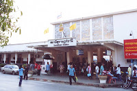
 The administrative offices of the district and the municipality are located close together, and both not far from the train station. While the district office is of the standard style of these offices, the municipal office is a very plain office building. I even at first misidentified that office with the hospital next to it, which from the satellite image looked much more representative.
The municipality was created in 1955 as a sanitary district, and was upgraded to a subdistrict municipality in 1986. In 2000 it finally received the town status (thesaban mueang), which it still has today.
 The district Phunphin was one of the original ones of the province. The southern part of the district was at first a separate one named Phum Duang (พุมดวง) before 1917 and then Tha Rong Chang (ท่าโรงช้าง), and was merged into Phunphin someday between 1917 and 1938 - sadly I haven't yet found the relevant Gazette announcement on this. The only thing on the history of the district I could find in the Gazette archive was its rename from Tha Kham to Phunphin in 1939 (Gazette), however according to the district list of 1917 it was named Phunphin, so I am lacking another name change announcement.


No comments:
Post a Comment