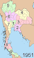
 As mentioned before, the four regions which existed in the 1940s were changed into 9 regions in 1951. What makes this interesting comes clear when one compares the regions with geocodes of the provinces today - the first digit of these is exactly the region number the provinces belonged to.
Well, not completely, there are three deviations. At first, Samut Prakan and Uttaradit changed the region in 1955, however for the geocode only half of this change was used. Samut Prakan has geocode 11, and was reassigned from region 2 to 1 in 1955. Uttaradit however has geocode 53, but was reassigned from region 5 to 6 in 1955. The third one is Nong Bua Lam Phu, which was created in 1993 and received the geocode 39. However the parent district Khon Kaen belonged to region 4. The reason why it got a different number is quite simply the fact that all number from 40 to 49 were already used; also 38 is still left free which also shows that the 39 actually belonged into the forties. Maybe they should have used hexadecimal geocodes, as soon as they create more than one new province in the northeast the numbers will run out. Also the central region 1 is full already with geocodes. I don't want to list all the provinces with their regions here, so if the maps aren't enough simply look at the ISO 3166-2 standard defining the geocodes.

No comments:
Post a Comment