
 |
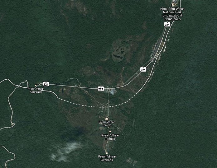
| Preah Vihear area with disputed boundary line, Google Maps |
The other place on the Thai-Cambodian boundary where it has quite a tense situation between both armies over yet another Khmer temple ruins is Prasat Ta Muen Thom, where (at least from the Thai view) the boundary is beyond this temple, but the current boundary displayed the ruins right into Cambodia - and here there's not even a dotted line. Ogle Earth's analysis of this new feature in the maps also mentions these two Thailand examples.
But keep the nationalist furor down - Google does not define the national boundaries, they only try their best to show them in their great software, so this latest step of showing where there are disputes and a clear boundary cannot be shown is the right next step. They only need to identify all of the places where the boundary isn't clear yet. And that's not easy, not only are there these two locations where the boundary is disputed between Cambodia and Thailand, also quite recently I learned from an article in The Nation that there are also many issues lingering for the Thai-Burmese boundary. And back in 1984 there was even a short military fighting at the Thai-Laotian boundary over two villages, not sure if at least this part of the Thai boundary is completely settled by now.
Such boundary issues will also complicate the setup of Geograph Thailand, since it is impossible to decide which 1x1 kilometer square belongs to Thailand and which one not. And since most of the boundary is in dense jungle and also often not allowed to enter anyway, let alone to cross it at any place except the official border crossing, it won't be possible to take as many boundary photographs as I did at the German-Dutch boundary in the German Geograph - thanks to Schengen the country boundaries in Euroland are often hardly noticeable.
But while the country boundary is the easiest to create misunderstandings, actually for me much more interesting would be more accurate boundaries of the administrative subdivisions. Google Earth does show the Tambon boundaries, Google Maps only the province boundaries, but better accuracy of these would be high on my wishlist. For a forthcoming posting I was trying to find the boundary of Tambon Talad in Surat Thani city, and Google is quite off from the actual location of the boundary - though it is by far not the only map with such big inaccuracies.
1 comment:
Yes Google don't show a border line at Ejderen (Die Eider);)
Post a Comment