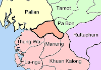
 The case which made me stop with the subdistrict maps was the north of Satun - the GIS website of the Satun provincial administration, amphoe.com as well as a SVG map show the district Thung Wa extending much further to the north and west than most other maps, where this area belongs to Palian district of neighboring Trang province. And even the recently added Tambon boundaries in Google Earth confirm this. The area in question is drawn in orange in the map depicted.
 Later I found another location where the provincial boundaries seem to got changed, and that is Lopburi, where the district Lam Sonthi in the east of the district seems to have lost its northernmost part to Wichian Buri district in Phetchabun Province. Or maybe on the other hand this was never part of Lam Sonthi, just wrongly drawn like that. The Lopburi tourism map from TAT shows Lam Sonthi extending quite far to the north reaching till Phakdi Chumphon, whereas the 1983 topographic map of the area shows it reaching north till Si Thep district. Besides, some maps show Dan Khun Thot in Nakhon Ratchasima directly border Lam Sonthi, while others like the one I used for the map here have a small part of Sikhio between the two.
However I haven't yet found any announcements in the Royal Gazette online search which would confirm these changes, the last change with respect of provinces was done in 1984 when a village was exchanged between Yasothon and Roi Et. Right now I am quite busy with other tasks like the Royal Gazette, but I would love to find authoritative boundary maps to return to create more maps as well. And there's also the copyright issue - I somehow doubt that drawings of such administrative boundaries are copyrightable, as they are created by the government and such acts are in the Public Domain in Thailand.
I guess that the maps produced at the Royal Thai Survey Department would be authoritative, but I did not succeed in finding maps simply showing the administrative boundaries down to subdistricts level there. Yet one I could find: the map index to find the order number for the 1:50000 maps is actually a SVG file which contains all the district boundaries. That one shows Lam Sonthi even shorter, not reaching Si Thep at all. For the Satun case it confirms the larger Palian, but it completely lacks the district Manang created in 1996, so I cannot trust that map either.

No comments:
Post a Comment