Wednesday, December 31, 2008

Digest of administrative changes in 2008

As the year ends soon and everyone is doing year-end retrospectives, I also join in and just like last year post a digest of the changes with respect of the administrative entities in 2008. While it was a very turbulent year in Thai politics - four different governments, the silent coup by the military not following the government, and of course all the damage done by the airport blockade. But for the actual topic of this blog not that much happened, only few things were announced in the Royal Gazette this year, most of the changes were municipal changes which so far were only published in the meeting transcripts and still wait for the official publication.

I am listing the changes by the type of entity affected instead of the chronological way these were already announced in this blog over the year.
  • Villages: The renaming of seven villages were announced.
  • Municipalities:


    • Three TAO upgrades to municipalities were announced.
    • One municipality area change was announced
  • Subdistrict: For announcements with refined definition of boundaries were published.
Not published were the most of the changes for the municipalities. The numbers I posted before already are for the fiscal year however, which begins October 1.
  • 339 TAO upgraded to subdistrict municipalities
  • 2 TAO upgraded to town
  • 9 subdistrict municipalities upgraded to town
  • 5 municipalities were renamed
  • 26 TAO were renamed while being upgraded to municipality
Happy new year 2552...

Tuesday, December 30, 2008

Tambon area clarification in Saraphi, Chiang Mai

Published today was an area clarification for the subdistrict (Tambon) San Sai (ตำบลสันทราย), Saraphi district, Chiang Mai province. The announcement was published in Volume 125, Issue พิเศษ 197 ง on page 21 to 23, signed on November 3 and published on December 30. Note sure if there will be anything published tomorrow, so this is likely the last announcement to be mentioned here for this year.

The only thing I can use from this announcement for my data is the village list included, giving the names of the 12 villages as follows. However actually I could have taken that list also from the website of the TAO San Sai.
หมู่ที่ ๑ บ้านสันทรายท่าช้าง
หมู่ที่ ๒ บ้านป่าสา
หมู่ที่ ๓ บ้านท่าสองแคว
หมู่ที่ ๔ บ้านศรีดอนชัย
หมู่ที่ ๕ บ้านท่ามะขาม
หมู่ที่ ๖ บ้านหนองแบน
หมู่ที่ ๗ บ้านปิงน้อยหลวง
หมู่ที่ ๘ บ้านปิงน้อย
หมู่ที่ ๙ บ้านปากคลอง
หมู่ที่ ๑๐ บ้านสันทรายมหาวงค์
หมู่ที่ ๑๑ บ้านล้องปู่หม่น
หมู่ที่ ๑๒ บ้านต้นผึ้ง

Friday, December 19, 2008

Contradicting maps

I created quite a lot of simple maps for the province and district articles on Wikipedia, to help to localize the entities geographically. However when I started to do maps showing the subdistricts (tambon) within one district, with a small number representing the geocode of the tambon, I soon ran into problems. There are just very few maps available online which show the boundaries of the administrative entities, and also the digital maps from ThinkNet only have district boundaries as the lowest level. About one year ago Google Earth started to show the subdistricts as well. But even those few map sources sometimes contradict quite strikingly.
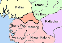
Map of Satun-Trang boundary areaThe case which made me stop with the subdistrict maps was the north of Satun - the GIS website of the Satun provincial administration, amphoe.com as well as a SVG map show the district Thung Wa extending much further to the north and west than most other maps, where this area belongs to Palian district of neighboring Trang province. And even the recently added Tambon boundaries in Google Earth confirm this. The area in question is drawn in orange in the map depicted.

Later I found another location where the provincial boundaries seem to got changed, and that is Lopburi, where the district Lam Sonthi in the east of the district seems to have lost its northernmost part to Wichian Buri district in Phetchabun Province. Or maybe on the other hand this was never part of Lam Sonthi, just wrongly drawn like that. The Lopburi tourism map from TAT shows Lam Sonthi extending quite far to the north reaching till Phakdi Chumphon, whereas the 1983 topographic map of the area shows it reaching north till Si Thep district. Besides, some maps show Dan Khun Thot in Nakhon Ratchasima directly border Lam Sonthi, while others like the one I used for the map here have a small part of Sikhio between the two.

However I haven't yet found any announcements in the Royal Gazette online search which would confirm these changes, the last change with respect of provinces was done in 1984 when a village was exchanged between Yasothon and Roi Et. Right now I am quite busy with other tasks like the Royal Gazette, but I would love to find authoritative boundary maps to return to create more maps as well. And there's also the copyright issue - I somehow doubt that drawings of such administrative boundaries are copyrightable, as they are created by the government and such acts are in the Public Domain in Thailand.

I guess that the maps produced at the Royal Thai Survey Department would be authoritative, but I did not succeed in finding maps simply showing the administrative boundaries down to subdistricts level there. Yet one I could find: the map index to find the order number for the 1:50000 maps is actually a SVG file which contains all the district boundaries. That one shows Lam Sonthi even shorter, not reaching Si Thep at all. For the Satun case it confirms the larger Palian, but it completely lacks the district Manang created in 1996, so I cannot trust that map either.

Thursday, December 18, 2008

Special administration area of Pattaya

Pattaya is an administrative entity unique in Thailand, though similar with the normal municipalities (Thesaban) its actual local administration is covered by a special law. This includes an elected mayor since the creation of the special area in 1978, something only adopted to the municipalities with the revision of the Thesaban act in 2000. I haven't yet found a good list of the further differences between the two administration systems.

In a 1998 issue of the Pattaya Mail it has the following short news.
In a very short time, Pattaya will become a self-governing 'Thesaban Nakorn', or city. This is due to the failure experienced during Pattaya's 20 years as a 'special city'. The government has seen fit to 'move backward' and make Pattaya a 'Thesaban Nakorn' to which Thai people are accustomed.
Apparently this change of the city status was not done, as still today it has its special status. It is a pity there are no further details on this plan in that article, especially interesting to know why it was skipped.

Wednesday, December 17, 2008

8th national and social development plan of Thailand

Some quotes from the 8th national and social development plan of Thailand (1997-2001), to be exact I am quoting from Part IV "Enhancing the development potential of the regions and rural areas to promote better quality of life" , Chapter 4 "Regional and Rural Development Administration", Paragraph 1 "General Development Administration", on Page 71-72).
1.7 Enhance the capabilities of local administrative organizations, particularly tambon administrative councils, so that they can more effectively implement the policy of decentralization of prosperity.

(1) The government should act as a supporter to enhance the capabilities of local administrative organizations, and cooperate with them in the elimination of certain problems which it is beyond their present capabilities to deal with independently.

(2) The Master Plan for Local Financial Management and the Master Plan for Monetary and Fiscal Policies for Social Development should be implemented in order to encourage decentralization of benefits of development to local areas and hasten fiscal reforms, particularly the collection of taxes based on actual circumstances. Under this reform, local administrative organizations should gain sufficient revenue to finance the economic and social development of their respective communities.

(3) Support should be provided to local administrative organizations in terms of personnel, budget and necessary equipment, so as to facilitate implementation of the policy of decentralization of prosperity.

Tuesday, December 16, 2008

City pillar shrines outside provincial towns

City pillar shrine of TrangWhen I wrote about the city pillar shrines the first time, I shortly mentioned the three cases I knew where it had a city pillar shrine not located in a provincial capital. By some random googleing I found the blog of Sing, and while introducing his hometown Kantharalak he also posted photos of the city pillar shrine there. This now makes it the fourth of these shrines not in the provincial capital.
  • Phra Pradaeng, Samut Prakan. The city pillar shrine is quite old already, and continued to exist after the province was abolished in 1932.
  • Trang's city pillar shrine (see photo) is still located at the original location of the town, which was moved first to the coast and later further inland at the beginning of the 20th century.
  • Mae Sai, Chiang Rai. Might date back to the time when Mae Sai was a Mueang (though not one reporting directly to Bangkok) and not yet incorporated into Chiang Rai province as a district.
  • Kantharalak, Sisaket. Might be similarily old, according to amphoe.com Kantharalak goes back to Mueang Uthumphon Phisai.
Below is a Google Map with the location of those shrines I either visited already, or could proof the location. On a scrapbook at Wikipedia I already collected more, including information on the history of each building though that is hard to find without reading Thai. Though that page is not an article, it can be edited by anyone like almost every page on Wikipedia, so if you can share information you're welcome to put it right there. I have also created a photo album with all my city pillar shrine photos.

View Larger Map

Monday, December 15, 2008

Samui Express mixing up local and central government

When I wrote about misconceptions on the Thai administrative structures shortly ago, this was done by a foreigner who did not research enough and fell into some traps I fell myself at first as well, like the confusion of "tambon" vs. "thesaban tambon". But - I just discovered that the newspaper Samui Express made it even worse when they reported about municipal upgrade.

The article was published on October 20, just four month after the upgrade actually happened. Just to quote the worst parts
Up until June 2008, the island was an amphoe (district) of Suratthani province, then subdivided into seven sub- districts (tambon) with the complete island being one municipality, or sub district. Now, the sub-district has been changed to “town municipality.”
The island still is a Amphoe (district) and is still subdivided into 7 subdistricts now. The only small truth hidden in it is the fact that the subdistrict headmen (kamnan) lost their position, together with the village headmen (phu yai ban), but still the subdistrict and villages are kept.
In the past, Koh Samui reported as a “sub-district” to Suratthani, rather than Bangkok. While still operating as a “sub-district,” one of 19 in the province of Suratthani, Samui submitted the request be made a “city.”. However, that request was revoked and instead, the “town” municipality status was granted.
Completely mixing up the structures here. 19 is the number of district within Surat Thani province, of which Samui was and still is one. The number of subdistrict municipalities however was 21 (there are now 22, since 2 were newly created in July), together with 2 towns and one city. I made a very complete post about the local government in Surat Thani in May. While mixing up the facts, the article mentions the fact that at first city status was planned, but it was changed to town status - but it fails to state interesting part, the reasons for this change. I am quite disappointed to read such a nonsense in a Thai newspaper, the only excuse I can find is the fact that the article was written by an expat and not by a Thai, but even an expat should research more before writing an article and spreading such wrong information.