Fellow Wikipedian Michael Brückner, now working at the Naresuan University in Phitsanulok, in his working blog posted about two papers co-written by him. Though I can only access the second on GIS in Thailand, one of the problems they are trying to address is the identification of toponyms with the actual location, something which I also often have problems with during my work with the administrative entities.
As I am now only using Thai sources at least the problem of the plethora of romanization schemes does not affect me, and where I use "English" names to make it easier to read I exclusively use the RTGS (Royal Thai General System of Transcription), which though it has its weaknesses is at least a standard. But spelling changes in Thai are also possible, not just the temporary spelling reform of the 1940s, but also minor changes, like an added or removed ะ, or the omission of a silent last letter, both does not changes the pronunciation at all. One example can be the spelling change of Thep Nimit in Kamphaeng Phet, which changed from เทพนิมิตร to เทพนิมิต in 2005. Strangely I can only find the announcement for the rename of the TAO, but not the one for the subdistrict itself. And there are also accidental misspellings, sometimes even in the Royal Gazette. But as I work through the entities mostly manually I can identify the entities in these cases much easier than a computer would do with a simple search.
However much more work are the real name changes, and even worse name exchanges between two entities. Most problematic are names where I cannot find any current corresponding entity, and no source for a renaming or abolishing. One example is the minor district Hua Hin (กิ่งอำเภอหัวหิน) in Tak Province, which was created in 1906. And this announcement is the only thing I have found about this minor district so far. Its parent district Chiang Ngoen was downgraded to a minor district before 1917, and at an unknown date abolished completely. The only thing how I can link this Hua Hin to the present day entities is its main tambon Wang Hin, which is now under Mueang Tak district, same as the tambon Chiang Ngoen. I haven't yet lost my hope to find more about this minor district in the Gazette, but at least among the announcements I could find by searching for the titles there is nothing yet.
Monday, June 30, 2008
Friday, June 27, 2008
Local government entities of Phuket province
As Phuket is one of the smallest provinces it's very easy to give a complete listing of the central and local administration divisions in a single posting without becoming too lengthy.
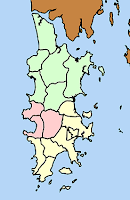 For the central administration it's three districts, Mueang Phuket (เมืองภูเก็ต), Kathu (กะทู้) and Thalang (ถลาง). These are further subdivided into 17 subdistricts, and 103 villages. Not all of the subdistricts have villages however - Talad Yai and Talad Nuea as part of the city Phuket, and Pa Tong as part of the same-named town don't have this subdivision anymore. I am not sure about Kathu, the city website lists 14 chumchon instead of the 8 muban it had in my latest list.
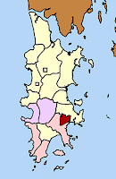 The local government entities are more diverse and has experienced more changes recently. Right now there are nine municipalities, one city (Phuket, ภูเก็ต), two towns (Patong, ป่าตอง and Kathu, กะทู้), and six subdistrict municipalities: Karon (กะรน), Choeng Thale (เชิงทะเล), Thep Krasattri (เทพกระษัตรี), Ratsada (รัษฎา), Rawai (ราไวย์) and Wichit (วิชิต). There are further nine Tambon administrative organizations (TAO).
Originally, Phuket had 13 TAO - of which twelve were created in 1995, and Pa Khlok (ป่าคลอก) in 1996. Karon had been merged into the subdistrict municipality Karon in 2004, and the other three Ratsada, Rawai and Wichit were upgraded into subdistrict municipalities effective August 30 2007.
Of these TAO, Karon, Thep Krasattri and Choeng Thale cover (or covered) only parts of a subdistricts, as the other parts are covered by a municipality. The others cover the complete subdistrict. For the municipalities it's the other way round - Phuket covers two subdistricts, Thep Krasattri and Choeng Thale parts of a subdistrict, and the other six each a whole subdistrict. Originally, when the sanitary district Kathu was created in 1956, it covered only part of the subdistrict Kathu. In 1967 it was enlarged to include the area of Patong, and in 1986 Patong became a separate sanitary district, so since then both cover exactly one subdistrict.
Though I have listed Kathu as a town above, in fact it will become a town effective July 14, as decided into the board meeting 33/2008. Phuket was upgraded to city status in 2004, Patong to town status in 2002.
Phuket was already a town since 1935, the other municipal areas as of today started as either TAO or as one of the five sanitary districts created between 1955 and 1987. Patong was the first of the sanitary districts to be upgraded to a subdistrict municipality in 1994, the other four were upgraded in 1999 when all the sanitary districts of Thailand were upgraded.
Finally, two TAO were created in 1955 - Ratsada and Si Sunthon (ศรีสุนทร) - but I am still not sure yet when this first generation of TAO was abolished again.
So below is a map with those local and central government offices I know so far. I could find two of the TAO with PointAsia, the district offices and those within Phuket city I had looked for quite some time ago to geotag the Wikipedia articles. Any additions or corrections to this map is of course welcome.
View Larger Map
 For the central administration it's three districts, Mueang Phuket (เมืองภูเก็ต), Kathu (กะทู้) and Thalang (ถลาง). These are further subdivided into 17 subdistricts, and 103 villages. Not all of the subdistricts have villages however - Talad Yai and Talad Nuea as part of the city Phuket, and Pa Tong as part of the same-named town don't have this subdivision anymore. I am not sure about Kathu, the city website lists 14 chumchon instead of the 8 muban it had in my latest list.
 The local government entities are more diverse and has experienced more changes recently. Right now there are nine municipalities, one city (Phuket, ภูเก็ต), two towns (Patong, ป่าตอง and Kathu, กะทู้), and six subdistrict municipalities: Karon (กะรน), Choeng Thale (เชิงทะเล), Thep Krasattri (เทพกระษัตรี), Ratsada (รัษฎา), Rawai (ราไวย์) and Wichit (วิชิต). There are further nine Tambon administrative organizations (TAO).
Originally, Phuket had 13 TAO - of which twelve were created in 1995, and Pa Khlok (ป่าคลอก) in 1996. Karon had been merged into the subdistrict municipality Karon in 2004, and the other three Ratsada, Rawai and Wichit were upgraded into subdistrict municipalities effective August 30 2007.
Of these TAO, Karon, Thep Krasattri and Choeng Thale cover (or covered) only parts of a subdistricts, as the other parts are covered by a municipality. The others cover the complete subdistrict. For the municipalities it's the other way round - Phuket covers two subdistricts, Thep Krasattri and Choeng Thale parts of a subdistrict, and the other six each a whole subdistrict. Originally, when the sanitary district Kathu was created in 1956, it covered only part of the subdistrict Kathu. In 1967 it was enlarged to include the area of Patong, and in 1986 Patong became a separate sanitary district, so since then both cover exactly one subdistrict.
Though I have listed Kathu as a town above, in fact it will become a town effective July 14, as decided into the board meeting 33/2008. Phuket was upgraded to city status in 2004, Patong to town status in 2002.
Phuket was already a town since 1935, the other municipal areas as of today started as either TAO or as one of the five sanitary districts created between 1955 and 1987. Patong was the first of the sanitary districts to be upgraded to a subdistrict municipality in 1994, the other four were upgraded in 1999 when all the sanitary districts of Thailand were upgraded.
Finally, two TAO were created in 1955 - Ratsada and Si Sunthon (ศรีสุนทร) - but I am still not sure yet when this first generation of TAO was abolished again.
So below is a map with those local and central government offices I know so far. I could find two of the TAO with PointAsia, the district offices and those within Phuket city I had looked for quite some time ago to geotag the Wikipedia articles. Any additions or corrections to this map is of course welcome.
View Larger Map
Wednesday, June 25, 2008
Thai spelling reform and province names
Last year I stumbled upon a spelling reform while browsing through the Royal Gazette announcements. Some months later Rikker posted more details on this reform in his blog. What I did not notice back then was the fact that not only some words changed their orthography, especially the change of อำเภอ (Amphoe, district) to อำเพอ did spring to my eyes then. In fact, also some of the provinces got a revised spelling then, which I could now notice while working through an announcement on the regions which lists all the provinces.
The following is the list of all the provinces which changed spelling, with first the reformed and second the traditional/current spelling.
The following is the list of all the provinces which changed spelling, with first the reformed and second the traditional/current spelling.
- Nakhon Pathom - นครปถม instead of นครปฐม
- Phitsanulok - พิษนุโลก instead of พิษณุโลก
- Uttaradit - อุตรดิต instead of อุตรดิตถ์
- Nakhon Si Thammarat - นครศรีธมราช instead of นครศรีธรรมราช
- Surat Thani - สุราสตร์ธานี instead of สุราษฎร์ธานี
- Krabi - กะบี่ instead of กระบี่, this one however more looks like a misspelling
Monday, June 23, 2008
Regions of Thailand in the 1940s
 I just mentioned them when I talked about the statistical regions earlier, and as a matter of coincidence I now found them in the Royal Gazette as well - the regions which were the successors of the abolished circles (monthon). They were named Phak (ภาค), and were simply numbered, so it was simply ภาค ๑, ภาค ๒ and so on.
Though according to the original forum posting where I first about them, the regions were started in 1934 as a direct successor of the abolished monthon, the first announcement I could find so far in the Royal Gazette dates from 1941, when the four annexed provinces were included into the regional layout. At that time there were five regions - Central and west, east, northeast, north and south.
 1943 the layout was changed in the first two regions, region 1 became a southern region, while region 2 a northern central region. In March 1944 the two provinces of the capital, Phra Nakhon and Thonburi, were excluded from the regions, which was undone in October the same year. Another announcement of 1946 was issued to add the re-created provinces Nonthaburi, Nakhon Nayok, Samut Prakan and Samut Sakhon into region 1.
 In 1947 the four annexed provinces were returned to French Indochina, so these were removed out of the regions list. Additionally, as the province Kalasin was re-created, this was now also listed, but the basic layout of the four areas remained unchanged.
I intentionally titled the posting with 1940s, as the change of 1951 into 9 regions will be the topic of a separated posting. I also haven't yet found the official announcement to abolish the region in 1956.
Friday, June 20, 2008
Bangkok district museums
 In 2005 Bangkok Metropolitan Administration (BMA) has started a program to establish a local museum within every of the 50 districts, displaying items of the local history, the local handicrafts and culture. They are named พิพิธภัณฑ์ท้องถิ่นกรุงเทพมหานคร, which simply means "local museum Bangkok". If I read the website on this program correctly, so far 21 such museums were opened. In most cases these museums are within schools.
- Khlong San within the temple (Wat) Anongkharam
- Chom Thong, within Wat Yai Rom
- Thawi Watthana, within Wat Puranawa school
- Thon Buri, within Buddhist Sunday school within Wat Prayun
- Bangkok Noi, within Suwannaram Witthayakhom school
- Bangkok Yai, within Rit Narong Ron school
- Bang Khun Thian, within Khlong Phithaya Longkon school
- Bang Rak, within the Bangkok Folk Museum
- Rat Burana, within the Wat Phra Saert Sutthawat school
- Samphanthawong, within Wat Traimitr, the temple with the famous golden Buddha
- Nong Khaem, within Wat Si Nuan Tham Wimon
- Din Daeng, within Wichagon School
- Dusit, within the Kiak Kai children museum
- Din Daeng, within Wichagon School
- Bang Sue, within the temple school of Wat Soi Thong
- Bang Na, within Bang Na Nai school
- Phaya Thai, within the Public Relations Department
- Phra Khanong, within Wat Thamma Mongkhol
- Phra Nakhon, within the district office
- Yannawa, within Wat Khlong Phum
- Watthana, within the temple school of Wat Phasi
 Sadly the whole program seems to be not much promoted anymore, especially not in English. The website which I link above is quite difficult to find as the domain name bmalocalmuseum.com is not working anymore. There are also some broken links within it, and of course no English version. If there weren't the street signs the museums would receive even less visitors - when I visited the one of Bangkok Noi lately I wasn't not only the first to sign the guestbook for the day, but for 2 weeks (OK, it was around the Songkhran holidays then, so hardly any students brought there with their school classes). I've posted a report especially on that museum in my travel blog already, so you can get an idea of how these museums look like. I can only recommend to pay them a visit, too bad I have only been able to visit one of these museums (and that twice) so far.
Below is a Google map with all the locations of the museums listed above, as accurately as I could place them. Corrections or additions are of course welcome.
View Larger Map
Thursday, June 19, 2008
Muban rename in Surin province
Published today in the Royal Gazette are two announcement renaming villages (muban) in Surin Province.
Volume 125, Issue 70 ง on Page 156 is the rename of village 1 of subdistrict Samut, Prasat district, from Ban Ta Tuan (บ้านตาตวน) to Ban Thung Mon Tawan Ok (บ้านทุ่งมนตะวันออก).
Volume 125, Issue 70 ง on Page 157 is the rename of village 16 of subdistrict Dan, Kap Choeng district, from Ban Noi Phatthana (บ้านน้อยพัฒนา) to Ban Mai Rue Thong (บ้านใหม่เรือทอง).
Both name changes were already effective as of April 25, the same date they were approved for publication.
In both cases the announcements state that the rename was done because the village community voted in favor of the change, for the first one it additionally states that the old name is meaningless and has no historic roots, for the second that the new name is historically more correct.
Volume 125, Issue 70 ง on Page 156 is the rename of village 1 of subdistrict Samut, Prasat district, from Ban Ta Tuan (บ้านตาตวน) to Ban Thung Mon Tawan Ok (บ้านทุ่งมนตะวันออก).
Volume 125, Issue 70 ง on Page 157 is the rename of village 16 of subdistrict Dan, Kap Choeng district, from Ban Noi Phatthana (บ้านน้อยพัฒนา) to Ban Mai Rue Thong (บ้านใหม่เรือทอง).
Both name changes were already effective as of April 25, the same date they were approved for publication.
In both cases the announcements state that the rename was done because the village community voted in favor of the change, for the first one it additionally states that the old name is meaningless and has no historic roots, for the second that the new name is historically more correct.
Wednesday, June 18, 2008
Tambon area clarification in Sam Phran, Nakhon Pathom
Published in the Royal Gazette today - Volume 125, Issue พิเศษ 102 ง on Pages 22-70 - the subdistrict boundaries in Sam Phran district, Nakhon Pathom Province, were redefined. The announcement states that this adjustment of the boundaries was done by the provincial governor (ผู้ว่าราชการจังหวัด). The announcement was signed on April 22, and became effective with the publication. Sadly it does not state what was actually changed in respect to the boundaries before, but if I am not mistaken none of the 137 villages was reassigned, so it must be only minor changes.
Subscribe to:
Posts (Atom)